Summary
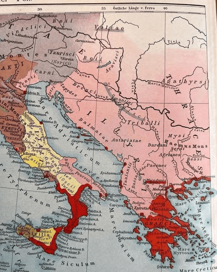
This old map of the ancient Balkans is not simply a geographical document; it is a historical testimony that speaks clearly, without rhetoric and without the need for forced interpretations. Built on classical Roman and Hellenic sources, the map presents the ethnic and cultural spaces of the ancient world, clearly separating Illyria from the Hellenic world and overthrowing many modern misconceptions that were later built on ideological grounds.
At its center lies Illyricum, a vast space that includes Dalmatia, Dardania, the Autariates, the Taulants, the Paeons and other Illyrian and Paleo-Balkan tribes. These names are not modern inventions, but evidence of ancient authors and the Roman administration, which treated these territories as a world separate from the Hellenic one. Illyria is not presented as someone else’s cultural periphery, but as a separate space, with a clear identity and historical continuity.
The red color on the map marks the Hellenic world, but it does not extend homogeneously over the entire Balkans. On the contrary, it is concentrated in the Peloponnese, Attica, the Aegean islands and in some specific coastal points outside this trunk. These points represent Hellenic colonies, not continuous ethnic territories. This distinction is essential, because colony is not equal to ethnic possession, nor to the extinction of the autochthonous population.
The map also shows something that is often forgotten in today’s debates: antiquity did not operate with national borders, but with spheres of influence, cities, trade routes and cultural areas. For this reason, modern attempts to transform every Hellenic trace into a territorial claim are anachronistic and historically inaccurate. This map itself, with its graphic clarity, separates cultural influence from ethnic reality.
Another important element is the language of the map: Latin and classical terminology show that we are dealing with a Roman reading of the ancient world, not with a modern national narrative. Rome recognized the Hellenes as a powerful cultural world, but treated Illyria as a separate political and administrative unit. This division was not accidental, but the result of reality on the ground.
In the end, this map reminds us of a fundamental truth: the ancient Balkans were a mosaic, not the exclusive property of a single civilization. Illyria and the Hellenic world coexisted, influenced each other, but did not merge into each other. Understanding this does not mean denying Hellenic culture, but placing it in its real dimensions, as history itself does.

