Information gathered from Sheradin Berisha’s article: https://pashtriku.org/sheradin-berisha-deputete-mos-e-shkilni-betimin/
Abstract
This abstract addresses the controversy surrounding the demarcation of Albanian lands with Montenegro, as discussed in the article “Deputetë, mos e shkilni betimin.” It examines historical, cartographic, and archival evidence demonstrating that the administrative border between Kosovo (former KSAK) and Montenegro during Yugoslavia followed clearly defined mountain peaks, including Starac, Çakorr, Hajla, and Zhleb, with official border crossings at Çakorr and Kulla e Zhlepit. Montenegrin post–World War II archival documents, geographic atlases, photographs, and customs stamps consistently confirm this boundary. The study argues that recent demarcation decisions contradict historical borders and have resulted in the transfer of territories to Montenegro and the forced displacement of Albanian families from areas such as Žleb and Çakorr, raising serious legal, historical, and moral concerns.
The demaracation of Albanian lands to Montenegro received criticism. Many maps, photographs, documents and other archival data prove that the administrative border line of the former Yugoslavia with Montenegro was as follows:
- Starac 2426 m,
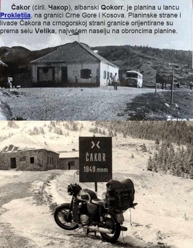
- Çakorr 1849 m,
- Planinica 2077 m,
- Usovishte 1932,
- Maja Dramodol 2119 m,
- Shtedin 2274 m,
- Zhlep 2382, while the border (crossing) points from KSAK to Montenegro were, in Çakorr and in Kulla e Zhlepit.
History of the Albanian-Montenegrin border
In a Montenegrin archival document, from after the Second World War, which describes the general data of the Border of the People’s Republic of Montenegro with Albania and the People’s Republic of Serbia (namely the KSAK), it is stated (I am quoting): “In the direction of the People’s Republic of Serbia, the border is crossed by the peaks (heights) Bogicevice, Cakorr, Hajle and Zhlep (Zhleb)”.
Montenegrin document states:
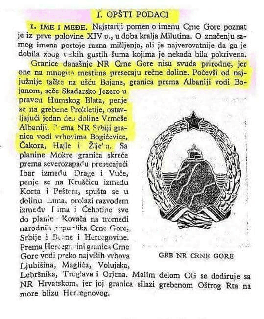
Translation:
“The borders of today’s People’s Republic of Montenegro are not always natural, as they intersect river valleys in many places. Starting from the southernmost point at the mouth of the Bojana River, the border towards Albania runs along the Bojana River, crosses Lake Skadar in the direction of Humski Blato, climbs the ridges of the Prokletije Mountains, leaving one tenth of the Vrmoša Valley to Albania. Along the People’s Republic of Serbia, the border runs along the peaks of Bogićevica, Čakor, Hajla and Žljeb”
This facsimile shows the “Kulla stamp”
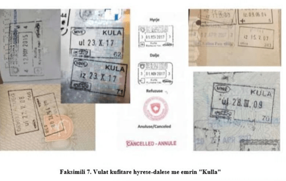
Translation: “The stamps of the border named “kulla”
In another Montenegrin material illustrated with photographs – where the object of the border point in Cakorr is seen, it is stated that: Albanian Cakorr is a mountain in the Nemuna (accursed) mountain range on the Montenegro – Kosovo border.
The facsimile with the note and photos:
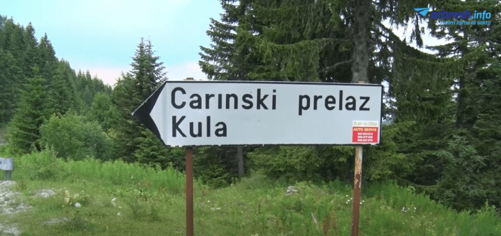
Also according to map number 32 published in 1961 in the Geographical Atlas in Zagreb, it turns out that the administrative border points between Kosovo (former KSAK) and Montenegro are in Ҫakorr (1849) and in Kulla e Zhlepit (2381).
The full map:
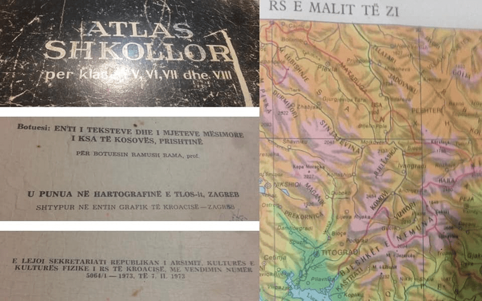
That the Kosovo – Montenegro border point is in Kulla is proven in the Atlas where it says: “carinski prelaz Kula” (Kulla border crossing) and the entry and exit border stamps with the name “kulla”. (See the photo and the facsimile with the border stamps.)
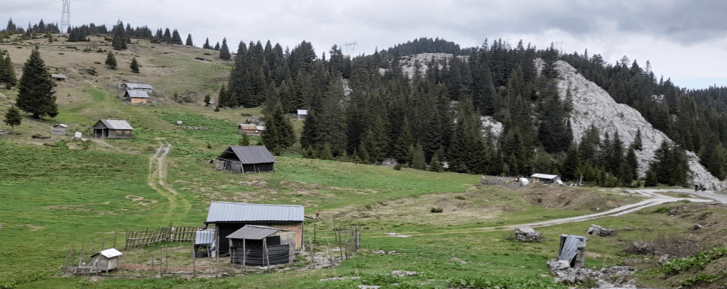
After the “Demarcation”, the Montenegrin authorities, having been granted the territories of Zhlebi, Lug te Shtjerrav, Ishtedim, Çakorr, Hajla, Stanet near Rugova, decided to expel the Albanian families living there. Arberesh.info published a short video on the matter.
Albanians forced to leave Zhleb

Video of the Albanian houses of Zhleb
Photos of Zhbleb and Çakorr