by Eli Eli.
Abstract
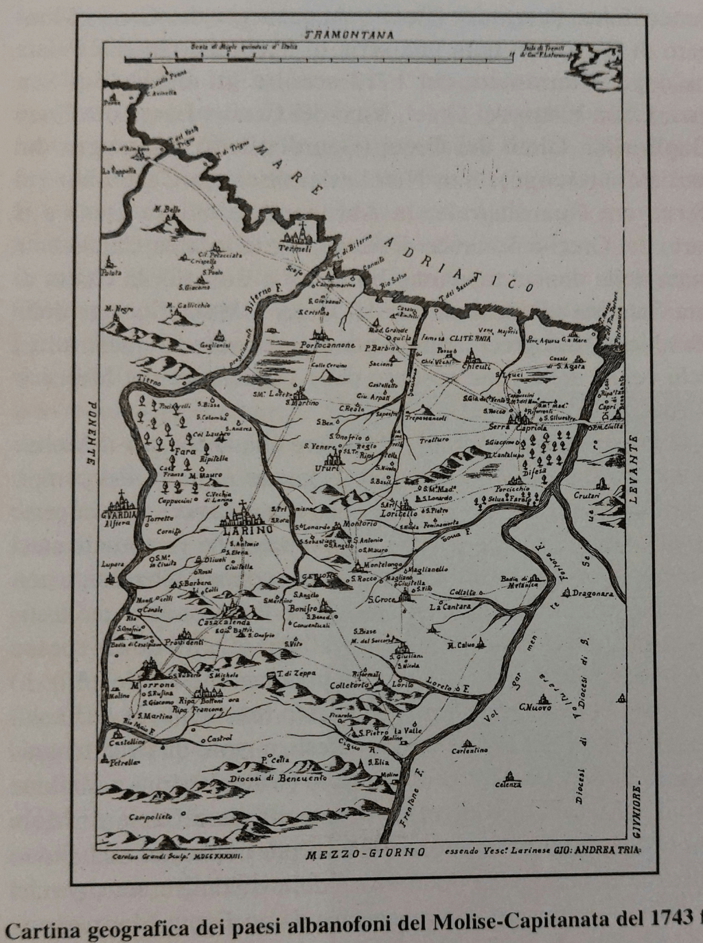
This study examines a 1743 geographical map documenting Albanian-speaking settlements in the Molise–Capitanata region of southern Italy. The map provides early modern evidence of the continued presence of Arbëresh communities established after Albanian migrations in the fifteenth and sixteenth centuries. Through its detailed representation of settlements, topography, roads, and diocesan boundaries, the map reflects both ethnolinguistic awareness and ecclesiastical-administrative interests. As a historical source, it contributes to the understanding of minority language persistence, regional settlement patterns, and the role of cartography in documenting cultural identity in early modern Italy.
Source and Date
The map is titled “Cartina geografica dei paesi albanofoni del Molise–Capitanata” and is dated to 1743. It was produced in southern Italy during the early modern period, when ecclesiastical and administrative cartography was commonly used to document linguistic, ethnic, and diocesan divisions.
Geographical Scope
The map depicts a region of southern Italy encompassing parts of Molise and Capitanata (historical northern Apulia). The Adriatic Sea is shown to the east, with coastal orientation clearly marked. The terrain includes rivers, mountain ranges, valleys, and coastal plains. Cardinal directions are indicated, with Tramontana (north) and Levante (east) explicitly labeled.
Topographical Features
Major rivers are drawn as thick, winding lines crossing the region from the interior toward the Adriatic Sea. Mountain ranges are illustrated using stylized hill symbols, particularly in the inland areas. Coastal zones are clearly delineated, emphasizing the Adriatic shoreline. Roads and paths connect settlements, indicating communication and movement routes.
Settlements and Urban Centers
Numerous towns and villages are marked, including inland settlements such as Larino, Guardialfiera, and Casacalenda, as well as coastal or near-coastal locations. Churches and religious buildings are symbolized, reflecting the central role of ecclesiastical structures in settlement identity. Many of the depicted villages correspond to historically documented Arbëresh (Albanian-speaking) communities.
Ethnolinguistic Significance
The primary purpose of the map is to identify and locate Albanian-speaking settlements in the Molise–Capitanata region. These communities were established mainly between the 15th and 16th centuries by Albanian refugees fleeing Ottoman expansion in the Balkans. By 1743, these populations retained their language, customs, and distinct communal identity, which the map explicitly records.
Ecclesiastical and Administrative Context
Diocesan boundaries are indicated, with references to dioceses such as Benevento and Larino. The map reflects the interest of church authorities in documenting linguistic and cultural communities under their jurisdiction. The presence of episcopal references suggests the map may have been commissioned or used for ecclesiastical governance or visitation purposes.
Historical Context
By the mid-18th century, Albanian communities in southern Italy had existed for nearly three centuries. The map demonstrates their continued demographic and cultural presence. It also reflects broader early modern efforts to catalog populations according to language, rite, and locality, particularly in regions with mixed ethnic composition.
Scholarly Relevance
This map serves as a valuable historical source for the study of Arbëresh history, early modern cartography, and minority language preservation. It provides spatial evidence for settlement continuity and offers insight into how linguistic identity was recognized and recorded by contemporary authorities.
Conclusion
The 1743 map is a systematic geographical and ethnolinguistic document that records Albanian-speaking settlements in Molise–Capitanata. Through its depiction of terrain, settlements, and diocesan structures, it offers a detailed snapshot of a culturally distinct population embedded within southern Italy during the early modern period.


