

Authors:
Qazim NAMANI, Dr. Archaeology/Cultural Heritage
Emin SALLAHU, MA. Cultural Heritage and Tourism Management
Kosovo Institute for the Protection of Cultural Monuments, Pristina
Abstract
The development of urban life in the Llap River valley, during various historical periods, was undoubtedly dictated by the geo-strategic position, agricultural land and mineral wealth of this area of central Dardania.
The fortifications built on the left side of the Prishtina-Besianë road undoubtedly created the defensive control system in the lower Llap River gorge, or the mountain gorge from the Llap Plain to the Kosovo Plain. These fortifications were built on the most strategic hills of this area, starting from Quka in the village of Barilevë, Kështjella in Lupçi e Poshtëm, Gradishta and Kështjella in the village of Majac, Gradishta and Shotori in the village of Llapashticë and Kështjella e Potoku. All these fortifications had a good view and communication with other nearby castles on the right side of the Llap River.
The strategic position of these fortifications, near the famous trade route Via Naissus-Lissus, which crossed the valley of the Llap River, we believe that these castles of this area played a very important role in the cultural and economic development of ancient cities. This region, rich in minerals and fertile soil, gained special importance after the Roman conquest and the economic development of Vendenis and Ulpiana.
Fortifications on the left side of the Llap River, along the Prishtina-Besianë road axis – archaeological traces in the village of Majac
In Kosovo, no detailed study has yet been conducted in the field of fortifications. For this reason, studies are scarce, especially for those fortifications in which life did not continue until the 18th-19th centuries, a period of the strengthening of the great Albanian pashaliks. We believe that the territory of today’s Kosovo, based on the limited data we possess , in terms of the style and architecture of the fortifications, does not lag behind other countries, but belongs to the community of the cultural treasure of the Illyrian Peninsula.
Fortifications were built at strategic points near roads and valleys with fertile soil, especially in areas rich in minerals, such as those of ancient Dardania.
The earliest fortifications in the Illyrian territories are known as Gradishte. These fortifications were usually built on lower hills, and covered an area of up to 1.5 ha. On the sides of these settlements where there was no natural protection, the hill was fortified with earth consisting of a mixture of soil, gravel and small stones. Such settlements protected by a surrounding earth, built of broken stones mixed with earth, were called “Gradina”, and the etymology of this word is of prehistoric origin. [1]
The settlements of the Dardanian cultural group from the 8th-4th centuries BC are of the hilly type, located on low hills or even high peaks. The most common names found in Kosovo for these settlements are: Gradinë and G(r)adishe. Their common features are their location on hills, which have steep sides on three sides, while on the opposite side, they are connected in a saddle shape to the lower hills. [2]
These names in the Illyrian territories come from early prehistoric periods, which according to some researchers mean the weaving of a settlement with earthen mounds in the shape of a fence.
Near these fortifications, in later historical periods, castles were built on higher hills and with a larger surface area.
During the 5th-4th centuries BC, in the fortifications that continued to exist from the early Iron Age, civic life developed. [3] From the sources of ancient authors, Titus Livius mentions three types of fortified settlements, namely: Urbes, Oppida and Castella. [4]
The fortifications built on the left side of the Prishtina-Besianë road undoubtedly created the defensive control system in the lower Llap River gorge, or the mountain gorge from the Llap Plain to the Kosovo Plain. These fortifications were built on the most strategic hills of this area, starting from Quka in the village of Barilevë, Kështjella in Lupçi e Poshtëm, Gradishta and Kështjella in the village of Majac, Gradishta and Shotori in the village of Llapashticë and Kështjella e Potoku.
All these fortifications had a good view and communication with other nearby castles on the right side of the Llap River, starting from Quka in the village of Milec, Trudë, Besi, Tenezhdoll, Rimanishtë, Siqevë, Grashticë, Koliq and beyond, which altogether formed the fortification system in central Dardania.
The strategic position of these fortifications, near the famous trade route Via Naissus-Lissus, which crossed the valley of the Llap River, in central Dardania, suggests that these castles in this area played a very important role in the cultural and economic development of the cities in this region.
This region, rich in minerals and fertile soil, gained special importance after the Roman conquest. The importance of this route is also evidenced by the discovery of a mile stone, on the banks of the Llap River, in the village of Lupç i Poshtëm, at the foot of the ancient Dardanian castle on the Kulina Hill. [5]
The Llap River, surrounded by fertile lands and avulial terraces, has played an important role in the initiation and development of life. [6]
In the 8th century BC, there was a culture with established features, which I am now certain belonged to the Dardanian culture. [7]
During this era, the Dardanians learned to process iron, which was extracted from the country’s mines. This developed culture has been discovered in hilly settlements and important strategic points, thus creating a system of observation, defense, and signaling fortifications among themselves. [8]
The development of urban life in the Llap River valley, during different historical periods, was undoubtedly dictated by the geo-strategic position, agricultural land and mineral resources of this area of central Dardania. The growth of economic activities in this region significantly influenced the urban development of the two ancient cities of Vendenisi and Ulpiana, and an extensive road network with control stations was formed.
A considerable number of objects have also been discovered in the Llapi region, which testify to the intensity of life during the Roman period, the center of which in this area was the ancient Vendenisi. [9]
The economic development of this area, which was evidenced by numerous archaeological finds from the Neolithic period in Prishtina, Dardhishte, Berrnica, Barileva, Siboca and Lower Lupca, and later, the economic development of the Kingdom of Dardania, was also based on agriculture, livestock and crafts. Livestock products, as well as Dardanian silver and gold, had become known to many coastal cities, in the east, the Mediterranean and the Adriatic, so these products were sent to these places via the Niš-Lezha road.
The traces of castles identified in this area reflect extensive defensive construction activity in Dardania.
Based on the results of the observational and identification reconnaissance , a lot of data has been collected about this area, but based on its economic and strategic importance, there is still room to identify new traces of civilization in this region.
Identifying the castles and describing them allows us to become familiar with the fortification system of Dardania in general, and should therefore be a priority for our future studies.
Since archaeological and ethnographic research is scarce in the northeastern region of present-day Kosovo, the cultural traces that have come to light to date testify to the tradition of cultural development in these areas, since the early prehistoric periods. The archaeological material evidence discovered to date convincingly indicates that the Dardanian ethnicity has survived foreign rule over the centuries, and continues to live in these areas as an indigenous population in its own ethnic lands.
As we mentioned, ancient written sources for this part of Dardania are scarce, so for many issues we are obliged to assume through the establishment of hypotheses, which are based on material culture to prove the preservation of the continuity of the indigenous Dardani population to this day in the Illyrian Peninsula.
We believe that in this paper we have contributed, at least a little, to filling the gap in identifying fortifications in this area.
Barileva’s Quka
The Barileva Gorge is the last hill of the Albanik mountain range, which falls from the right side of the Llap River, in the Kosovo Plain.
Based on the archaeological discoveries in “Arat e Kovaçve”, where we have encountered a high level of development of Neolithic culture, we can affirm that in the Bronze and Iron Ages, when settlements began to be established in the hills, this hill also became habitable next to this Neolithic plain settlement.
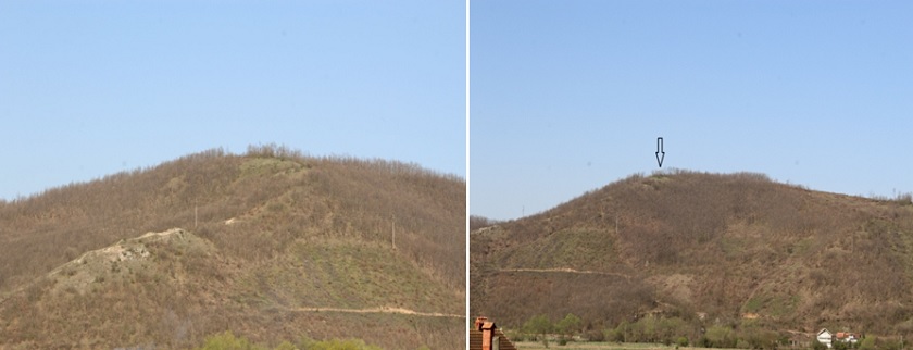
Barileva’s Quka, photographed from the east side
This hill has a very important strategic position to observe the movements along the roads that came from the Llap gorge, and those that came from the Ibar River valley, through Vushtrri and went towards the Kosovo plain. Also through this hill and the castle in Lower Lupci, during the period of antiquity, all movements that passed from the Llap gorge towards the Samadregja Castle and the Kosovo Plain were monitored.
From the eastern side, this hill also had good communication with the nearby villages of Trudë, Milec, Vranidoll and Besi.
Castle of Lower Lupci
This hill fort was built on the crest of the mountains, above the Barileva pass. From this observation point, good communication was possible with the system of fortifications that went towards Vushtrri and Trepça, and at the same time with all the nearby fortifications near Pristina in the Galab highlands.
So far, no archaeological excavations have been carried out in this castle, but based on the writings of archaeologist Edi Shukriu, and other sources on the ground, we can affirm that we are dealing with a settlement from the period of antiquity and the Middle Ages. Edi Shukriu writes that, A fortified settlement that lasted until the Middle Ages is also found in the castle located southwest of Lupç i Poshtëm. [10] Old roads from Vendenisi and the fortifications of this side went towards Vushtrri.
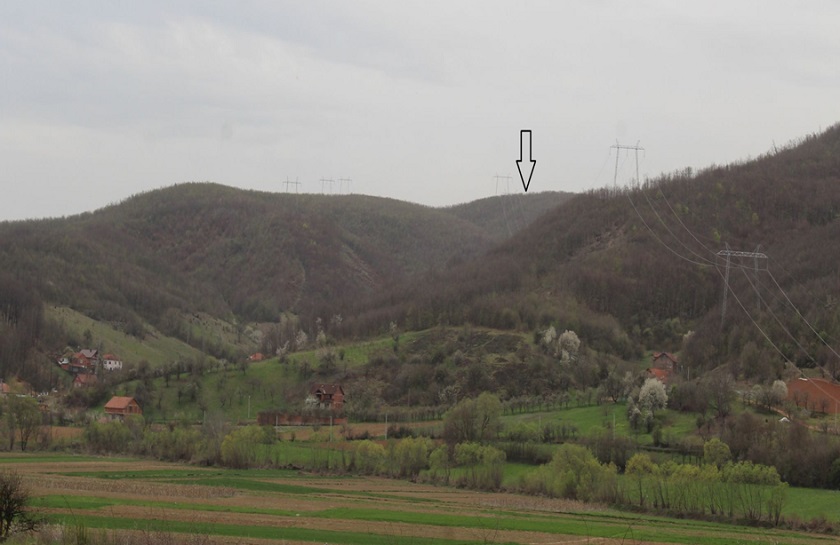
The Castle in Lower Lupci
Garden and Shelter in the village of Llapashtica
On the western side of the village of Llapashticë, on one of the hills, the Gradina of this village has been built. So far, no archaeological excavations have been carried out at this archaeological site, but based on the geographical position and the development of settlements of the Iron Age and antiquity around it, we can assume that we are dealing with a hill settlement, built during the Kingdom of Dardania in the Iron Age.
Not far from Gradina on the north-western side, on a higher dominant hill, is Shotor in the village of Llapashticë. This settlement is also an important archaeological and strategic point, which has not been investigated in archaeological terms, but all the findings of the case and other evidence allow us to believe that we are dealing with a fortified hill during the period of antiquity and the medieval period. It is also important to mention the Quka e Kodralive, in the village of Llapashticë, which we think was an observation point, near the tent and the village Gradina.
Edi Shukriu has also written about these fortifications, stating that the system of fortifications in the Llap area also included the hill towns west of the village of Llapashticë, west of Lupç i Epërm, and Kulina e Tenezhdollit. [11] In this case, when the town west of Lupç i Epërm is mentioned, we think that this should be Quka e Kodralive.
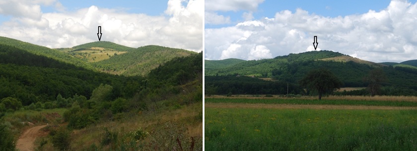
Photo 1. Tent, Photo 2. Garden in the village of Llapashtica
From this strategic point, the entire plain of Besiana is visible, and there is communication with all the fortifications in the south-east and north-east of Besiana. It is worth noting that in addition to the view and communication with the fortifications around it, this fortification also has communication with the well-known forts in the Malsinë e Galab such as: Qukë in Herticë, Brainë, Shotor in Kolliq, Kollçakut Castle in Koliq, Balloc Castle, Sukat in Rimanishtë, etc.
The fortifications of the village of Popovë
In the village of Popovë, there is the Potok Castle, whose surrounding walls can still be seen in the central tower. In addition to the Castle, other localities and toponyms worth mentioning are: Selishta on the south-eastern side at the foot of the Potok Castle, the old archaeological site Suka e Kodralive, which is thought to be an observation point for fortifications in the course of the Kaçanollit Stream, Guri i Bardhë, Gurina e Kishës, Kodra e Kunovikut, Ahishtës Stream, Kodra e Madhe, Gurina e Madhe and e Vogël, Rrahi i Mexhës, Ahishta e Pajas, Rrezja e Thanës, Lugu i Kishës in the Maçastena neighborhood, the Church under the Potok Castle, Pusi i Shkumës, Rruga e Kaurrve that passes near Selishta and ends in the village of Vesekoc, the municipality of Vushtrri, etc.
The geo-strategic position of the village, in a valley along the watercourse, with fertile fields and meadows, and with several mills and waterworks, proves that in Popova, at the foot of these strategic hills with good natural protection, there were very favorable conditions for the flourishing of an ancient civilization.
Based on the configuration of the terrain and the archaeological traces discovered so far, we can affirm that in the course of the stream, from the village of Lupcë i Poshtëm to the Potoku Castle in the village of Popovë, there was uninterrupted civilization from the Stone Age to the present day.
Potok Castle in Popova
Potok Castle is built on steep cliffs, rising from the village of Popovë, on the right side of the stream that flows from the village of Kaçanoll and flows into the Llap River.
The easiest access to this fortress is from the north-east, while the other sides have very good natural protection. On the west side there was very good natural protection, from the high hills of the village of Vesekoc.
This fortress has a very good view and controlled all movements from the south, east and north-east. Built on a significantly higher hill north of the Majac fortress, these two fortresses have a distance between them, approximately 8 km as the crow flies. Also, the Potok fortress which lies northwest of Shatori in the village of Llapashticë has a distance of approximately 5 km. With its strategic position, this fortress played the main role in communication and securing the population in case of danger in that area.
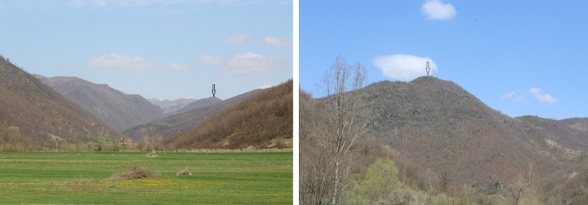
The Castle in Potok
The Potok Castle also has good visibility with Kulina in the village of Tenezhdoll and other distant fortifications in the Galab Mountains.
This fortified settlement has very good protection from the breaking of the terrain, with stone cliffs up to the Kaçanolli Stream, which makes it impossible to walk towards the castle from this side, so from this stream it was possible to exit to the castle only from the northern and eastern sides.
The front walls of the hill on the western side, starting from the south-east at Kerrshi i Sokolit, are so steep that they create very good natural protection. This line of the stream is crossed by several waterfalls, with fast flowing water. The steepness of the slopes of this stream is also indicated by their names such as: Kerrshi i Pelave, Kerrshi i Magarit (Gomarit) and Kerrshi i Sokolit. From other positions, and in the citadel, it is observed that the surrounding walls of the castle are made of unhewn stones and bound with lime mortar.
In the Kaçanolli stream, near Selishta and Potoku Castle, traces of metalworking and the foundations of a church have been found. The foundations of a church have also been found in the Segashë neighborhood near a road that went from Segashë to Vushtrri, which the population of these villages call “Kaurri Road”. Of course, this road had received this name during Ottoman rule, through which the Christian Dardanian population moved most, who did not submit to the Ottoman occupation until the end of the 19th century.
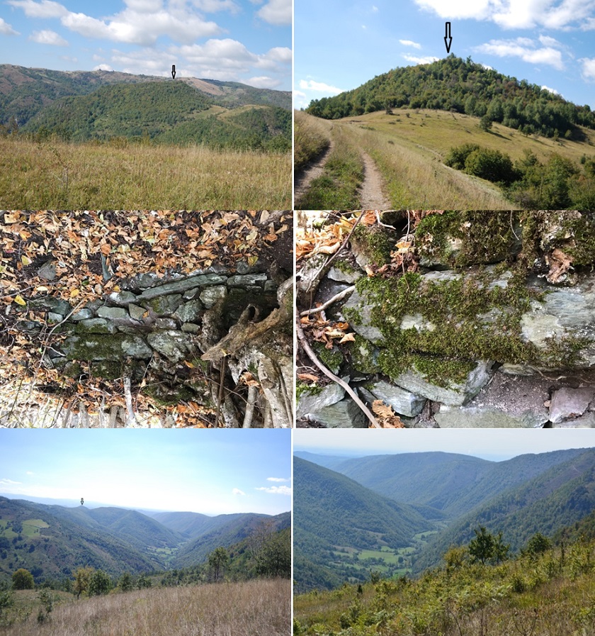
Photos 1 and 2, view of the castle from the east, Photos 3 and 4 The foundations of the castle citadel and the connection with lime mortar, Photos 5 and 6, Views from the east and south-east, descending from the castle
From the north and north-west, this fortress is bordered by the crown of mountains and hills of the villages of Kaçanoll, Bajgorë, and Vesekocë, where through observation points on these hills it communicated with the fortifications in the direction of Vushtrri and Trepça.
As can be seen from the data recorded on the ground for fortifications, but also from the configuration of the terrain that is being presented in this paper, we can affirm that this castle, deep in the mountainous areas, between Besiana, Trepça and Vushtrri, was one of the most well-protected castles in this area of Dardania.
Majac Village
The village of Majac is a settlement in the municipality of Besiana , located on the left side of the Pristina-Besiana road, at a distance of about 20 km from Pristina, and about 15 km from Besiana.
This village, with a very good geographical position for living, is nestled at the foot of the mountains and hills of Albanik (today’s Kopaunik). The Kaçanollit Stream, which originates in the high hills of the village of Kaçandoll, passes through the territory of this village, and is 33 km long until it flows into the Llap River. [12]
The territory of the village has the shape of a valley, which in the western and northern parts is surrounded by quite steep mountain ranges, while along the stream valley, it is mainly flat and very fertile land. The altitude above sea level is 560–850 meters. [13]
Micro toponyms in the village of Majac
Toponyms are an important part that shows the historical, social, linguistic, geographical, cultural past, preserved from early periods, to the present day, for a certain settlement or region. The collection of toponyms is of great importance for the study of a settlement. Great attention should be paid especially to the geographical ones, because they are data on the traces of the antiquity of the civilization of a population, in a certain area. Toponyms as traces passed down from generation to generation to the population that lived in a settlement, are the first evidence to research the traces of civilization in that region.
Among the toponyms that prove the autochthonous nature of the Albanian population in the Dardanian regions, and which we still encounter today, are: Gradishta, Selishta, Kulina, Suka, Quka, Kalaja, Hisari, Gomuri, etc. Although some of these toponyms take on linguistic forms, according to the systems and empires that have ruled a region for a long time, the preservation of the population’s memory of them, regardless of the official language spoken, testifies to the autochthonous nature of the population in a given territory.
The names for fortifications that are found today in Albanian territories, called kala or even Hisar, are recent, and do not diminish the idea of the autochthonous nature of the Dardanian population in these territories. Considering these data, even though several neighborhoods with different tribes live in the village of Majac, the preservation of the names since ancient times for Gradishte, Gomurë and Kala, show that the Dardanian population lived and operated in that settlement since prehistoric times.
The most important micro-toponyms of the village of Majacë are: Gradishta, Kalaja, Gomuri, Te Kisha, Livadhi i Abazit, Lugu i Musës, Kërshi i Majacë at Lugu i Musës, Shpella te Kërrshi, Keshë te Kërrshi, Roga e Malit, Lugu i Macës, Kulla (at the house of Fazli Rama, or Mustafa i Talit), Klisyra, Gërdeçi, Lugu i Kroit, Lugu i Karazmanit, Lugu i Madh, Lugu i Vogël, Lugu i Kovaçit, Roga e Ali Brahimit, Lugu i Shotave, Lugu i Firit, Lugu i Lamaës, Arat e Shkozë, Arat e Murrizit, Qestat, Gropat e Majdenit, Mbi Rrahë, Lugu i Baltave, Lugu i Hysës, Udha e Ustahit, Lugu i Kishës (on the borders of the villages of Majac and Sollobajë), Lugu i Ramë Tahirit, Klisyra e Maxhunit (Lupçi Upper), Livora Valley (Great Valley), Tomb Valley, Shota Valley, Fier Valley, Rragjagji Valley, Gjavelles Valley (lime was mined there), Mahallë Valley, Llapashtica Valley (During the rule of the Serbo-Croatian-Slovenian Kingdom, the road from the villages of Llapi to Trepça had begun to be built through this valley, so even today this road is called the Banovina Road), the hill above Gërdec is called Cikoli, from this hill you can see almost the entire Kosovo Plain, Lezhnica Gorge, Deli Creek, Qarri, Red Roads, Bukurdolli, Lam Binakut Mill, Kulla, Kronit Gerdeç Valley, Gjudes Stream, etc. [14]
Archaeological traces in the village of Majac
In the village of Majac, during agricultural activities and the construction of buildings, ancient traces of civilization were found. During the works in Arat e Rrahit, tiles and bricks from the ruins of an old settlement were found. Rrahinat are located on the left side of Kodra Gërrdeç, while the valley between Rrahinat and Gërdeç is called Klisyra.
At the Brahimi Çeltaku on Kodra e Gërdeç, precisely at Kroi i Lugut i Shahës, old water supply pipes were discovered, which led water towards Ara e Rrahut. Kodra e Gërdeç, where the water supply pipes were discovered, is opposite the Castle and the Gradina, on the left side of the stream, near the Lam Mill.
In the village of Majac, the Karazman Valley was a strategic settlement throughout time, through which various armies passed to enter this village, say the elderly villagers.
In the center of the village of Majac, right in the yard of Daut Berisha, in 1974, during the opening of a water well, at a depth of about 3 m, traces of an old settlement were found, but which had burned down residential buildings. In this case, along with traces of fire, metal tools and furniture of the residential building were found.
Also in this neighborhood, during the opening of a basement of a building, at a depth of about 1.5 m, the foundations and walls of a building were discovered, walled with large stones. The structure of the stones was similar to the stones that still emerge today at the place called Kërrshi i Majac, the villagers say.
Symbols of the sun and fertility cult in the cemeteries of the village of Majac
Prehistoric man knew himself, and nature with its phenomena, through the comparison of every object, action or sound that he saw and heard. Without this analysis of the differences and similarities of the world around, it would not have been possible for our ancestors to have the phenomenon of thinking.
This figurative language is the origin of the creation of symbols. Primitive man learned to distinguish the detail that clearly gave the essential characteristic of the figure, and at the same time of an idea that was related to the drawing of the figure. [15]
The solar symbol of the sun cult in the form of a disk is the most widespread representation among all ancient peoples. The finding of this symbol in our lands is proof that this cult symbol was quite widespread among the Illyrian tribes, but also in the Dardanian territories.
The spread of this symbol among the Illyrians was also written about by the Greek rhetorician of the 2nd century BC, then by Maximus of Tyre, who wrote that the Paeonians worship the sun, in the form of a small disk reinforced on a long stick. [16]
The sun, as a solar symbol, was considered in ancient times to be the life-giving god of light, dispelling darkness and melting frost. This cult, as well as the moon, are quite present among the Balkan peoples. [17]
In the cemetery of the village of Majac, there is an old grave, the age of which is unknown, but the villagers call it the “Holy Grave.” In this grave stands a vertical obelisk measuring about 2 m above the ground.
Obelisk – The obelisk’s top view is square, and this structure gradually becomes conical, with four sides, to end with a pyramidal top. Obelisks were made of stone blocks, which the ancient Egyptians extracted, excavated and erected in front of tombs and temples. Some of them are quite tall.
The largest that exists to this day, which is located in a square in Rome, is 32 meters high and weighs about 455 tons. Most obelisks are decorated with hieroglyphs. These monuments in Egypt were made to honor the sun god (Ran). It is thought that their shape was based on the shape of the pyramids. They represent the rays of the sun coming to warm and illuminate the earth. [18]
In 30 BC, Egypt became a Roman province. Various Roman emperors wanted to adorn their capital with famous monuments, so they brought about 50 obelisks from Egypt to Rome. This phenomenon was repeated in the 19th century, when after the conquest of Egypt in 1836, Napoleon Bonaparte’s army took an obelisk covered with hieroglyphs and pictographs from the Luxor Temple, weighing 250 tons and measuring 23 meters long, and carried it across the Mediterranean Sea to Havar, a city in northwestern France, then sailed down the Seine River to Paris and placed it in the Place de la Concorde. [19]
This phenomenon of the transfer of Obelisks is also evidenced by historical writings, which state that in 1829 the king of Egypt, Mehmet Ali Pasha, donated to France the two obelisks of the Luxor temple, which were erected in honor of Ramses II around 1250 BC, but one of them in 1836 went to the “Place de la Concorde” in Paris.
The glory of the obelisks lies not only in their artistic carving, but also in their long survival, faithfully preserving ancient Egyptian art and culture. [20]
Several Obelisks are known in the world, one of which is that of Sessos I, in Heliopolis. [21]
The tallest obelisk ever discovered, in one of the most famous quarries in Egypt, is the ‘Unfinished’ Obelisk, [22] taller than any obelisk ever known in history. The Unfinished Obelisk is the largest obelisk known from antiquity and is located in the northern quarries region of ancient Egypt at Aswan. [23]
In modern times, modern obelisks have been erected in several countries around the world, one of which is the modern obelisk erected in Washington, USA. [24]
In addition to this obelisk, several other Obelisks are also known in the world, such as: Obelisk in St. Peter’s Square, Vatican City, Luxor Obelisk, Paris, France – Concorde Square, Obelisk of Buenos Aires, Argentina, Lateran Obelisk, Rome, Italy, Cleopatra’s Needle, New York, United States, Luxor Obelisk, Luxor, Egypt, Heliopolis Obelisk, Cairo, Egypt, Flaminio Obelisk, Rome, Italy, Obelisk of Aksum, Ethiopia, etc. [25]
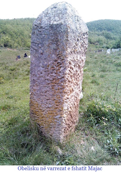 Let us stop at the “Holy Tomb” in the village of Majac, which was found to be marked with an Obelisk. Since so far, we have not known of such discoveries in the Dardanian territories, it is difficult to reach an accurate conclusion whether this Obelisk was imported from another country, or was produced in the well-known quarries of this village.
Based on the early traces of civilization that have been found nearby, without archaeological excavations having been carried out in this village, we can affirm that Majac is an early archaeological settlement, which preserves very valuable treasures of the ancient Dardanian culture. To give any scientific assumption regarding this finding, experts in this field can speak only after archaeological research in Gradina and the Majac Castle.
The four-sided stone pillars called obelisks taper upwards and end with a pyramid-shaped top. It is thought that the oldest obelisk in the world, which was built in ancient times to be used as a cult symbol, is about 4,000 years old, but even the youngest obelisk built for this purpose is about 2,000 years old. Based on these historical sources, this obelisk, however small, located in the cemetery of the village of Majac, is older than the beginnings of Christianity in our country.
Regarding the Obelisk in the cemetery of the village of Majac, we can say that it is not large, it does not have inscriptions or any cult symbols, it has the shape of an Obelisk, traces of stone carving are visible on its four sides, and at the top it ends in a pyramidal shape. Based on the composition and type of carved stone, with the stones at the top, we think that the Obelisk is a local product, and it leads us to think that the village of Majac is a very important archaeological site, which preserves ancient traces of the Dardanian civilization.
Other cemetery stones with cult symbols, which were found in the complex of a small family cemetery in the Isufëve neighborhood, in the center of the village, make us even more convinced that this village preserves very ancient traces of civilization, which argue for the high economic, social and cultural development of the Dardanian population throughout the centuries.
It is important to note that, even in this cemetery complex, a tombstone with three circles was found, which in pagan belief symbolizes the cult of the sun.
The three concentric circles, with a dot in the middle, undoubtedly represent a solar symbol of the sun, related to the behavior of this planet around its axis.
Archaeologist Edi Shukriu has also written about the appearance of this cult in the Dardanian lands, saying: The sun as a solar cult was rarer in the Neolithic era, while the appearances of this cult in objects began to dominate from the beginning of the metal age, and later it was particularly manifested in the Vuçidoll culture. [26]
The cult of the sun has also been found in use among the Dardanians. It has been attested to, especially in the discovered objects of the Iron Age, and in the architecture of the mounds. [27]
The solar cult of the sun is also associated with the parts of the scepter discovered in mound II in the village of Llashticë, and this cult is also found on the monument of the Goddess discovered in the village of Smirë. [28] The solar disk of the sun is also found on Illyrian coins of the Paeonët, and on coins minted in the city of Damastion. [29]
Based on these results of preliminary studies, we can affirm that the Obelisk and the stone with three concentric circles in the cemetery of the village of Majac, reinforce the idea that the Dardanians were worshipers of the cult of the god, along with other peoples with a high culture of civilization in antiquity. These cemeteries are on the right side of the road, at the foot of the Gradina Hill, about 100 m below the Majac castle.
Another tombstone with the symbol of the sun, with a circle, was discovered in the cemetery of the Dushve Neighborhood, in the village of Lupç i Epërm. This family cemetery is also on the left side of the road, about 100 m above the Majac Castle.
Based on this tombstone with a solar disk, we can affirm that these stones were brought from the ancient cemetery in Gradinë or Kala. Regarding the cemetery stones in Lupç, a resident of the village of Majac recounts how his ancestors told him that these tombstones had not been there before, but were brought during the night, and only in the morning were they seen in that cemetery. Sabit Dushi (1945), from the village of Lupçë, indicated that for their neighborhood, this is a stone from an unknown grave. As we can see, no names of the village residents who died during the 20th century are written on this stone, as happened in the nearby cemetery in the village of Majac.
At first glance, there are ancient traces of writing on this stone, so we can affirm that these stones belong to a very early period, having been taken from archaeological sites. According to Sabit Dushi, it is important to note that at the foot of Kodra Rrezja, there is Lugu i Kishës, where traces of its foundations were noticed until recently.
In the cemetery of the village of Majac, another stone was found, with the symbol of fertility, the triangle, and the Tree of Life.
The Triangle as a Symbol of the Vulva – The triangle plays a special role in the magical beliefs of many peoples of the world. This symbol is widespread from the ancient peoples of the Far East to the European peoples. As a symbol, it is also very often encountered in the Dardanian territories, starting from the Neolithic period to the present day.
The ancient Greeks used the triangle to represent the vulva, but it was also considered a divine symbol of fertility. In Christian symbolism, the triangle was a favorite sign to represent the eye of God and the Holy Trinity. In Illyrian lands, this symbol appears quite often. However, the basic function of this symbol is to graphically represent the female genital organ, writes Aleksander Stipceviqi. [30]
If we carefully analyze the tombstone that has the Vulva (Triangle) and the Tree of Life, we see that the symbol of the cross appears on the upper branches of the tree. This leads us to think that these tombstones are thousands of years old.
As can be seen, in this new family cemetery complex, these two stones with ancient cult symbols were found, but based on the writing of the names of the family members and the year of their death, it is seen that these stones have been placed in these cemeteries since the mid-20th century.
Due to our limited knowledge of the terrain, we have had the opportunity to encounter other cases where tombstones from ancient cemeteries have been brought to new cemeteries and placed in family graves, without any knowledge of the ancient symbols and writings.
In one case, we even came across a woman’s tombstone with an Ottoman inscription, brought by a citizen and placed at the head of his father, who had died at the end of the 20th century. Considering this fact, but also the existence of these cemeteries at the foot of Gradina Hill, we think that these two stones in this place were also brought from the archaeological sites of Gradina, Kalaja, Gomuri, Livadhi i Abazit, or some other locality in the area.
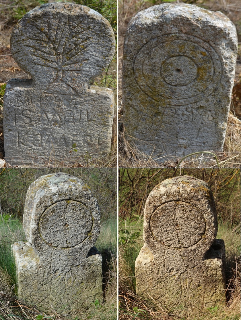
Photos 1 and 2, Symbols of the cult in the cemetery of the village of Majac and Photos 3 and 4, Tombstones in the village of Lupç i Epërm
It is important to know that from this neighborhood of Majac, the road that divides to go to the village of Lupç i Epërm, about 1 km, on the right side of this road is the archaeological site of Livadhi i Abazit (Leshnica).
After the occupation of Kosovo by Serbia, Slavic settlers were brought to live in the archaeological site of Livadhi i Abazit. After the settlers settled in these meadows, previously called Leshnicë, they took the name Lezhnica. A family of settlers was also brought to the central part of the village, and with this project the goal of the Serbian government was the Slavicization of Albanian settlements.
It is also important to note that the preservation of traces of civilization and toponyms in these areas provide sufficient evidence to argue the autochthonous nature of the Arbëro-Dardan population that lived in these areas for thousands of years. After the occupation of Kosovo by the Serbian army in 1912, although some toponyms took on their meaning in Slavic languages, the autochthonous Albanian population, together with the Albanian families that settled in these villages after the eastern crisis of 1878/79 from the Sandzak of Niš, jealously preserved the Dardanian material culture and the ruins of fortified settlements in this area.
Among our people, rites related to the cult of vegetation, as symbols of fertility, were numerous and were celebrated at every important agricultural and livestock festival of the annual cycle. [31]
Culture is a tradition that has developed over centuries, as a way of life, as a social food that guides the economic life of humanity. In traditional society, of peoples without writing, the direction of knowledge and lifestyle, economic resources, spiritual life, artistic and technical creativity is dominated by ethnoculture. [32]
Popular culture constitutes a system of values, historically formed and developed in close connection with the life of an ethnic community. [33]
With the carved oak tree on this tombstone in the village of Majac, we understand the motif presented that has an indirect connection with the development of the family or tribe, during different historical stages. The motif of the tree carving on the stone, does not always coincide with the tree, but there is an artistic expression that has been called the “Tree of Life” since ancient times, understanding this as a figure of prosperity and development of a family or ethnicity. These expressions of ancient motifs keep alive the symbolism of the survival of a people.
In many drawings presented on rocks, walls of residential buildings, amulets and other archaeological finds, discovered in the Dardanian lands, the triangle (Vulva) is found as a symbol of fertility, therefore this proves the ancient culture of development in our country.
The garden is magical.
Gradina e Majac was built on the ridge of a small hill, which rose on the edge of the stream that comes from the village of Kaçanoll, and passes through the village of Majac, near Gradina and the castle and flows into the Llap River. The inhabitants of the village know this hill by the name Gradina. In all likelihood, a fortified Dardanian settlement was built in this locality, since the Bronze Age, and was part of the group of earthen fortifications that were built in the Illyrian territories at that time. Gradina was built on the northern side of the village, at the foot of the steep hills that rose to the north, west and south. On the eastern side, this hill had an open view towards the village of Majac and Lupç i Poshtëm.
Within this fortification area, even today, structures of the construction of the ledhes can be seen, which were built by surrounding the settlement with small stones, mixed with earth. These settlements were built near fertile lands, and were used to shelter in cases when the local population was threatened by invasions of other tribes.
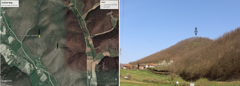
Photo: Aerial view of Gradina and the Castle and photo of the castle, from the southern side of Gradina
Majac Castle
Majac Castle is built on the rocky ridges on the first hill that rises north of Gradina , on the border with the village of Lupçi i Epërm. The castle and Gradina are separated only by a small stream. Based on the first visit we made to this fortification, we can note that the surrounding walls are built of unprocessed stones, which are connected with limestone mortar. So far, no archaeological excavations have been carried out in this castle to highlight its cultural and historical values.
This three-terraced fortress, within the surrounding walls, has a fairly large area, and the surrounding walls of the fortress fall quite low, on the slope of the hill on its southern and eastern sides. The fortress has an easier access from the north-eastern side, while from all other sides the terrain has a fairly steep slope. At the entrance to the fortress we noticed two moats made of earth before going to the central tower. This construction technique leaves the impression that we are dealing with a very developed urban fortification during the time of antiquity. The eastern side of the fortress borders Gradina and from the citadel there is a very good view of the other fortifications around it. On the north-eastern side of the fortress is Gomuri (Kodër Varre) which is thought to be the ancient cemeteries of the population that once lived in Gradina and Kala.
In the citadel of the castle, the outlines of the surrounding walls can be seen, while the outer surrounding wall of the castle, on the south-eastern side, was discovered in 1999 by the residents of the upper neighborhood of the village who still live at the foot of the hill of the castle on the south-eastern side.
The residents of this neighborhood, while building a shelter for their families, during the 1998/99 war, when Serbia was attacking Albanian settlements, came across the surrounding wall of the castle. After receiving this information, we visited this shelter and there we noticed that we are dealing with the surrounding wall of the fortification.
The wall was about 2 m thick, and continued on the slope of the hill somewhere around 100 m from the surrounding walls of the citadel. We found fragments of pottery, and the wall made of ordinary stones and connected with mortar. From first impressions, we think that we are dealing with a fairly large fortified urban settlement built during Roman rule.
This castle from the east has a very good view of the Tenezhdolli Castle, the Suka of Rimanishtë, the Shator in the village of Koliq, from the north-east it has a view of the shator in the village of Llapashticë, from the west above this castle another castle in Potok was built which also has a fairly large space within the walls of the citadel and is thought to be the largest and most important fortification in that area of the Dardanian territories. On the south side through the steep hills and the castle in Lower Lupçi, the Majac castle communicated quite well with the Samadregja Castle, Barileva and other fortifications that were built in the area of Vushtrri and Trepça.
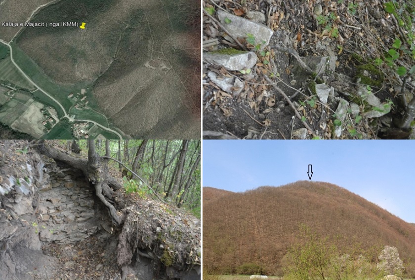
Photo 1. Aerial view of the castle, Photo 2. Traces of the foundations in the citadel, Photo 3. Foundations of the surrounding walls discovered in 1999 and Photo 4. Photographed from the eastern side
The construction of this fortification on the northern side of the Tenezhdoll Castle undoubtedly had a strategic protective character for the population that lived in this locality, therefore it is of scientific interest that archaeological research be conducted in this settlement, to shed light on the historical and cultural importance of the fortifications in the Dardania region.
At the Tenezhdoll Castle, which is about 10 km away, research has been carried out, where early historical artifacts have been discovered. The Tenezhdoll Castle is built on a hill on the right side of the Prishtina-Besiane road axis and the Llap River. The old ancient Niš-Lezha road also passed near this castle. This Castle has a good geographical position and an altitude of 670 – 685 m, [34] with very good visibility with the Majac Castle and other castles around it.
References
[1] Hysen Kacillari, Toponymy of Devoll – Co-author of the origin of history and the Albanian language, National Center “Our Roots”, international assembly, Historical-Linguistic and Ethnocultural Continuity of Albanians through the millennium, Book of References 1, Tirana 2019, p. 287
[2] Edi Shukriu, Dardania Para Urbane, Peja, 1996, p. 30
[3] Gjerak Karaiskaj, “5000 years of fortifications in Albania”,Tirana 1981, p. 5
[4] Zef Miredita, “Dardan Studies”, Prishtina, 1979, p. 112
[5] Fatmir Peja, The Ethnocultural and Historical Heritage of Llapi, Prishtina, 1995, p. 69
[6] Edi Shukriu, Material Culture of the Llapi Region, Albanological Research, Prishtina, 1990, p. 8
[7] Po aty, fq. 11
[8] Po aty, fq. 11
[9] Po aty, fq. 14
[10][10] Po aty, fq. 15
[11] Po aty, fq. 11
[12] https://sq.wikipedia.org/wiki/Majaca
[13] https://sq.wikipedia.org/wiki/Majaca,https://gyaanipedia.fandom.com/wiki/Fshati_Majac,https://sq.shops-net.com/99044/1/majaca.html
[14] Sources from residents, during the visit to the village of Majac, on 29. 11. 2009. Contact person Daut Berisha
(1943), Brahim Krasniqi and Xhafer Isufi
[15] Fatbardha Demi, Selenism-The Faith That Rules the World, Tirana, 2016, p. 31
[16] Aleksandër Stipçeviç, Illyrians, History, Life, Culture and Cult Symbols, Prishtina, 1990, p. 290
[17] Agim Bido, Popular Art in Clothing and Textiles, Tirana, 1991, p. 62
[18] https://www.jw.org/sq/bibliotek%C3%AB/revista/g200704/Nga-Egjipti-n%C3%AB-qytete-rreth-bot%C3%ABs/
[19] http://www.albaniapress.com/lajme/21141/UDHETIMI-I-OBELISKUT-PREJ-LUKSORIT-NE-PARIS.html
[20] After
[21] Fatbardha Demi, Selenism – The Faith That Rules the World, Tirana, 2016, p. 164
[22] https://paradoks.info/keto-jane-10-mrekullite-antike-qe-ende-mbeten-mister/,
[23] https://kzburn.info/chart/the-mysteries-of-the-longyou-caves/1riOrtJulZmkgmA.html,
[24] https://sq.wikipedia.org/wiki/Obelisk,
[25] https://ndertimi.info/arkiva/10-obelisket-me-mbreselenes-nga-e-gjithe-bota/,
[26] Edi Shukriu, Institute of History, Kosovo, Dardanian Goddesses – Iconography of Monuments, Symbols and
functions, Prishtina, 2004, p. 19, https://www.academia.edu/1787800/Dea_Dardane_-_Ikonografia_dhe_funksunet_2004 ,
[27] Po aty, fq.20
[28] Po aty, fq.20
[29] Po aty, fq. 20
[30] Aleksandër Stipçeviqi; Illyrians, History, Life, Culture, Symbols of Cult, Prishtina, 1990, p. 366
[31] Mark Tirta, Albanian Mythology, Tirana, 2004, p.288
[32] Mark Tirta, Albanian Ethnology, Tirana, 2003, p.23
[33] Po aty, fq. 24
[34] Haxhi Mehmetaj, The Ethnocultural and Historical Heritage of Llapi, Prishtina, 1995, p. 61

