Summary
The toponyms recorded in 15th- and 16th-century Ottoman census registers (defters) in the Vranje region provide evidence of an Albanian-speaking population’s early presence and continuity in ancient Dardanian territories. Many place names—such as Buka, Bukur, Katun, Kacapun, Kalimance, and others—can be meaningfully explained only through the Albanian language, indicating linguistic and demographic persistence despite centuries of foreign rule.
The following examples serve as evidence that, through toponyms, demonstrates the presence and continuity of an Albanian-speaking population in the Vranje region since at least the early 16th century.
Despite centuries of Roman, Byzantine, and later Ottoman rule in the Dardanian territories, a number of toponyms have survived that can be meaningfully explained only through the Albanian language. These place names indicate the preservation of both the language and the local population’s continuity in the area.
Such evidence challenges Serbian historiographical claims that Albanians only began settling in these regions in significant numbers during the 16th century. It also contrasts with the positions of certain Albanian authors in recent decades who, in their monographs on local settlements, have aligned with the view that Albanian families migrated to the Dardania region (as far as the Niš area) only in the 17th and 18th centuries, supposedly after leaving earlier settlements in the Shkodra highlands.
Serbian scholars have noted difficulty in explaining several local toponyms, including: Buka, Bukur, Punu, Katun, Kacapun, Kalimance, Muksul, Rogovo, Paskač, Livadhet e Bukës, Qelishtë, Turishtë, Çuka, and others. Many of these names have clear or plausible Albanian linguistic roots (for example, Bukë – bread, Bukur – beautiful, Katun – highland pasture settlement, Kalimance – roughly “passing by the side”).
Additionally, some Albanian institutions have proposed adding “Buka e Misrit” (Corn Bread) to the list of protected cultural monuments — an initiative that has been officially documented and signed by the Minister of Culture. This has been viewed by some as an unusual or lighthearted example of cultural heritage protection.
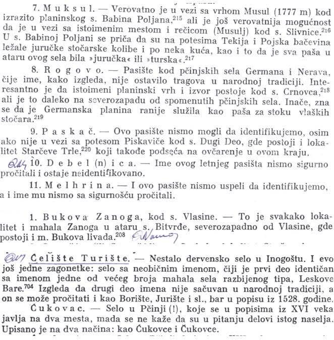
Image 1 transcribed:
7. Muksul. — Probably in connection with the peak Musul (1777 m) which is shown on the plan of Babina Poljana,²¹⁵ but there is still the possibility that it is in connection with the summer pasture and the stream (Musulj) near Slivnica.²¹⁶ In Babina Poljana it is mentioned that on the property of Tekija and the Polish beys there were some shepherd’s huts or some houses, as well as that the entire pasture was white from “jurucha” or “turska”.²¹⁷
8. Rogovo. — The pasture near the villages of Germana and Nerava, whose name, as it appears, has not left a trace in folk tradition. It is interesting that it is mentioned as a summer pasture peak and a spring near Crnovac,²¹⁸ but it is far to the northwest of the mentioned villages. Otherwise, it is known that the Germanska planina earlier served as pasture for the livestock of the local shepherds.²¹⁹
9. Paskač. — We were not able to identify this pasture, except that it is mentioned in connection with Piskavica near St. Dugi Deo, where there is also the locality Starčevo Tre,²²⁰ which is also located on the edge of this region.
10. Debel(n)ica. — We are not sure about the name of this summer pasture and it remains unidentified.
11. Melhrina. — We have not managed to identify this pasture either, and we have not read its name with certainty.
1. Bukova Zanoga, near the village of Vlasine. — This is certainly a locality and the small Zanoga meadow at the Vlasine lake, northwest of Vlasine, where there is also the Bukova livada.²⁰⁸
Qelishte Turishte. — It became a Dervish village in Inogošte. I have one note: the village with an unusual name, whose first part is identical with the name of one or more villages of the dispersed type, Leshko Bare.⁷⁰⁴ It appears that from the other part of the name it is not connected with folk tradition, and it cannot be read or connected with Borishte, Jurishte, etc., but it appears in the 1528 census.
Çukovac. — A village in Pčinja (!), which appears in the 16th century under two names, and in the 16th century it is mentioned in two ways: as Çukove and Çukovec.
Image 2:
Bujanovac. — A village in Moravica, recorded in 16th-century censuses as Bujanovce.
Bujkovac. — A village in Inogošte, recorded in 16th-century censuses as Bujkovce. Under the same name it also appears in the census of the army of the end of the 15th century.⁸³³
Buka. — This village is mentioned only in the 1528 census, but the writer of the census did not transcribe it accurately. It could be read as Boka, or even Bota (Buta). In any case, the question of where the village was and where it should be sought remains unresolved. It is assumed to be near Donjeg Jabukovac, northwest of Vladičin Han, near the place known as Semenska buka.³³⁴
Bukorovce, Gornje i Donje. — Villages in Morava, one of which is certainly today’s Bukorovce, southeast of Preševo. There is also today’s Loše Bukorovce, which may also indicate one of the locations of the old settlements.
Punuševce. — A village in Pčinja, which appears in 16th-century censuses as Polnoševce. The village is also mentioned in the 15th-century army census as Plnoševce,⁶⁰⁵ and in the Pčinja monument as Plnoševo.⁶⁰⁶ In 1878 the village was divided into two parts, with the border between Serbia and Turkey.⁶⁰⁷ In the part of the 1570 census, the uninhabited parts are recorded.
Katun. — A village in Moravica (!), which in the 16th century perhaps lay on the site of Staro Selo.⁴⁶⁶ The village is also mentioned in the 15th-century army census and in the Pčinja monument.⁴⁶⁷
Kacapun. — A village in Inogošte, which appears in 16th-century censuses under the characteristic name Kačapurče. At the time the village was probably located in one of the two places under the name Selište, in the area of today’s village.⁴⁶⁹ In the 1528 census it is not mentioned, probably the census writer missed it, or it was perhaps still a very small settlement. It is mentioned in the 15th-century army census, also as Kačapurče.⁴⁷⁰
Kalimance. — A Dervish village in Inogošte, in the immediate vicinity of Vladičin Han. In the 1528 census the number of households of the village is not recorded, which is not the case with others, which is quite unusual. Perhaps it is a question of the census writer’s error, or it was not included and previously it did not have its own settlement, but rather was a dependent hamlet of a neighboring village. The village is mentioned in the 15th-century army census, also as Kalimance,⁴⁵⁷ which means that at that time it was a mahala (hamlet) of this settlement.

Source
Dr. Qazim Namani’s research
Toponymic Study of the Vranje Region. Serbian historical-toponymic analysis of Ottoman census registers (defters), mid-20th century. Scanned pages from original publication held in user’s collection.

