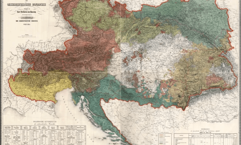

Croats do not need to justify themselves to anyone, but since we need to relearn and rebuild our entire history (and not let others build it for us, as they have done so far, mostly with lies, deception, and mostly slander), it is good to look at this data. It also draws attention to the fact that Orthodox Christians lived normally with Croats for centuries until the Serbian Orthodox Church and the mythological system that all Štokavians were Serbs got involved. Prosperov Novak and Marko Jurič have described this genesis of evil since the 19th century in a new book, which you can hear more about here .
In the video below, we bring you a video and a link to the map itself. This is a map in German from 1851. According to this map, you can see the number of inhabitants in each of the twenty-two areas of Austria-Hungary by nationality. You can see the number of Croats in Dalmatia, Military Krajina, the joint area of Slavonia and the then Croatia, and in other areas. The last column is the total number of inhabitants in these areas. Here you can see that Boka Kotorska and Dubrovnik were part of Dalmatia , and you can see how far Dalmatia goes.
History
According to this map, Dalmatia includes Boka Kotarska.
Here we see the name Sebo Kroatine, Sloveno Kroatien, Serbien, Slavonien, and finally, Sirmiem. Serbien extends beyond the territory of the triune Kingdom and it is not clear what it signifies. The following is the structure by major nationalities in Dalmatia, Military Krajina, Slavonia and the then Croatia, in Istria which is together with the wider area, and the number of Croats in all other areas. We see that in Dalmatia, Military Krajina, Slavonia and Croatia the share of Croats was sixty-eight percent, there were no Serbs in Dalmatia, and Istria was managed together with the wider area.


On the map, there are names that by area include the word Serbian (Serbo – Kroatien, Serbien), what does this mean? These markings seem to indicate that the map is not focused on the territorial representation of administrative borders and their names, but on the ethnic representation on the territory of Austria-Hungary. If you look down, you will see a legend that indicates nations by color.
That’s how Serbs and Croats wear the same green color. Those letters do not exclusively denote the dominant color in a certain area, because Slavonia is also mentioned, but there is no Slavonian as a nationality. Only with that does “Serben und Kroatien” make sense in the area above Dalmatia to the north, because there is a significant number of Serbs there, so that can explain the letters on the map.
Sources
https://crodex.net/austrijska-karta-iz-1851-g-srba-u-dalmaciji-nema/

