

By Dr. Qazim Namani
The Galab Mountains, this mineral-rich region, lies in the central part of the kingdom of Dardania. From the sources of ancient authors, we have inherited information about the ancient Dardanian tribe, the Galabrians, who are believed to have lived near the mines in the Galab Mountains, in central Dardania. Based on these sources, it is believed that the name of this mountain has been preserved to this day, of course undergoing changes by the conquerors of these lands, with names that were adapted according to their official language.
The geographical extent of this highland begins from the Morava River, from the Konuçli Gorge, to the Prokuplje and Leskoc plains.
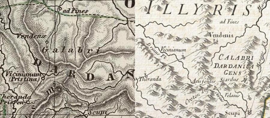
Maps showing the spread of the ancient Dardanian tribe Galabri in present-day Malas of Galab
This highland with a very important geostrategic position, between the Kosovo Plain and the Niš Plain, in the central part of the Dardania kingdom, became the center of administrative development, in the period of antiquity. As a region with low hills, rich in minerals, this region played an important role in the economic and cultural development of the Dardanians, at the time of the Dardania kingdom. As can be seen from many sources, the Galabri were the most important tribe, inhabiting the central and north-eastern part of ancient Dardania.
Researchers associate the name of these mountains with the present-day geographical region of Gollak (Gallabit Highlands), which is divided by the present-day border between Kosovo and present-day southern Serbia, where over half of the territory of this highland remains within the borders of present-day Serbia.
The Galabri (Latin: Galabri ) were an important Illyrian tribe, which was part of the Kingdom of Dardania . According to the ancient geographer Strabo, the population of ancient Dardania was divided into several tribes, but the most important were two tribes: the Galabri and the Thunates, about which ancient authors, before our era such as Strabo etc., wrote.
Strabo writes: Dardanians are also the Galabrians, among whom…, there is an old city. [1] I think that this city should be sought around the city of Niš, present-day Kusumlija or in the highlands of present-day Galab.
Some later scholars have written that: The Galabrians were a Romanized Thracian-Illyrian tribe of Dardania, along with the Thunates. They held territory in an important region of eastern Kosovo, southern Serbia, and northern Macedonia, with the city of “Vendenae”. Strabo writes that they are a “people of the Dardanians, in whose land there is an ancient city”. The Galabrian tribe has been linked by some scholars to Calabria in southern Italy. [2]
The movement of the Dardanian tribes, and other ethno-cultural elements, from north to south, is also discussed by many scholars, the similarity of toponymy in Italy and Illyria, Peloponnese and Asia Minor, has aroused interest in studying. For example, since antiquity in Dardania, the ancient author Strabo (Str. VII.5.7 – PAPAZOGLU 1969: 439, D 81) mentions two Dardanian tribes, namely the Galabri and the Thunates, and whose analogy is still found today in southern Italy: the Galabri, from which the present-day Calabria also took its name [3]
The Galabri are mentioned as a Dardanian tribe, a group that shared cultural and linguistic characteristics with the other tribes of Dardania. The Dardanians, as mentioned by Strabo, were one of the three most powerful Illyrian tribes, along with the Ardians and the Autariates.
This indicates that the Dardanians were an organized and developed society in this region. Although information about the Galabri is limited, their mention by Strabo indicates the presence of an organized and developed population in Dardania during the period of antiquity.
The possible connections of the Galabri, with the name “Calabri” and the toponym “present-day Gallapi” suggest a cultural and ethnic continuity in the region, contributing to the rich mosaic of Balkan peoples during antiquity. [4]
Zef Mirdita quotes Gerka Novak who wrote that Strabo is the first author who considers the Dardanians to be Illyrians. [5]
The Dardanians were organized in political, economic, and social life, and it seems that the ancient polis of Arhaia was an important center of the Dardanian tribe known as the Galabroi, which Karl Paci locates without a precise definition. [6]
The tribal name Galabri/Galabrioi has been linked to the name Mesapi (Mesapët), an ancient Illyrian tribe in Calabria (Calabrioi), in Puglia (southeastern Italy). It has also been linked to the Albanian toponym Gallapi in present-day northeastern Kosovo (Artanë). [7]
Johan Georg von Hahn, when visiting the lands of Llap and Gallap, writes that: These Arnauts (Albanians), are also called Lapë and Gulap, and that the land that Albanians inhabit today was an integral part of ancient Dardania, and the Dardanians were undoubtedly Illyrians. The Galabrians are the wildest of all other peoples. This name reminds us of the name of the Dardanian tribe Galabroi, where Galabereja is the name given to the flower that blooms on the slope. [8]
During the 19th century, many Slavic authors wrote and worked extensively on the change of toponyms and the appropriation of cult objects and Dardanian heritage in Southeast Europe.
Let’s look at some of the Serbian authors who, after the second half of the 19th century, acted in the field, changing toponyms, and appropriating Dardanian material culture.
According to Milos S. Milojevic, we understand that the name of this highland from Galab, attempted to be called Golube, and even with this name in the middle of the 19th century, they decided to call it Vrajë, but MS Milojevic, after visiting these mountains, wrote that from today these mountains will be called Golak (bare mountain without forests). Milojevic published the toponyms and sources collected in Albanian territories, with the aim of falsifying and Slavicizing them, in three of his notebooks, in 1871 and 1872. [9]

The naming of this highland as Gollak, by MS Milojevic. [10]
Another Serbian author, Mita Rakic, who visited the Albanian lands of Galab, after the conquest of these lands by Serbia, in his book “Iz Hove Serbije”, quotes the book of Johan George von Hahn, how he described the lands in the Galab Highlands, but he made an attempt to justify the alleged earlier name of this highland, Golubac, according to the writings of MS Milojevic, and the daily politics of many Slavic authors, for the Slavicization of toponyms in Albanian lands.
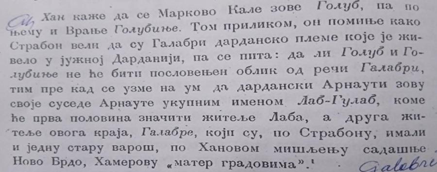
Mita Rakic, description from Han’s book about the Galabri. [11]
Mita Rakic describes the Vraja Castle and the city under the name Golubac [12] , where his mission to deny the old name of the Galabroi tribe and the Galab Mountains is clearly evident.
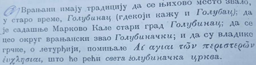
Mita Rakic writes that the city of Vraja in earlier times was called Golubac [13]
Browsing through Mita Rakic’s book, we understand that the population of this highland, including Toplice, was entirely Albanian, but here we notice the changes of names in many settlements. In this specific case, it is noted that the name of the village of Buka is changed to Buca, probably from some Western map, where the letter “K” is written with the letter “C”.
If we analyze the names of the settlements of the Galab Highlands, from the Niš Plain to the Kosovo Plain, we notice that the basic names of the settlements in these areas were in the Albanian language.
From some Serbian authors such as Mita Rakic, we learn that this highland until 1878 was ethnically inhabited only by ethnic Albanians, and he even writes about Kushumli that it was a nest of Albanians, and that pure ethnic Albanians live there . [ 14]
Important for us is that on many maps, and by many Western authors who researched or described the settlements of Albanian territories, they have left notes that this territory was once called Dardania, and in the central part of Dardania, the name of the Galabi tribe and highland is also described.
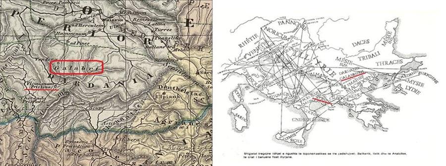
The first map of Dardania seen here is from 1865, created by Justhus Perthes (Ref. 1)
The second map of the movement of indigenous tribes, seen in the next section, is from 1961, created by Zacharie Mayani.
The traces of civilization in this region are visible, it is enough to single out Justiniana Prima, Justiniana Seconda, Vendenis and the castle of Artana, as a continuation of civilization between these urban cities of antiquity. In addition to urban cities, this region is characterized by many fortifications and sacred (religious) objects, which testify to a developed civilization, in all periods of history.
From an archaeological point of view, this territory belongs to the north-eastern region of the Artana castle, a very rich mining area, and with numerous traces of galleries and slags, which have remained on the surface of the earth, during the processing of minerals. In 1996, in Rapuha of Krileva, I found a hand-made stone Pukë, a gray ceramic piece, handmade, crudely crafted, believed to belong to the late Neolithic period, and traces of an ancient settlement.
In Rrapushe there is also a large amount of slag, left over from metal processing. Along the road on the eastern side from Rapuhe, going to the locality called Bara, in the upper neighborhood of Krileva, human remains have been discovered, the population of Krileva calls that place “The Illyrian Cemetery”.
From Rapuha, the hill that rises on the western side is called Gjyteti i Mareci-Krilevas, an archaeological site where archaeological excavations have been carried out, and it has been proven that we are dealing with a castle, which has a good view of the Artana Castle, the Strezoc Castle and other castles in the area.
Rapuha is separated by only a hill from the Gllogovcës Gjytet, an archaeological site that, from the findings of the case, has been proven to be an important settlement from the period of antiquity.
Above Rapuhë, about 300 m along the stream that comes from the village of Prapashticë, right in the stream that comes from Kodra e Liteci (called Lutesh in the Middle Ages), is the location where the tombs of Gjyteti are located. From the tombs of Gjyteti to the mountain “Straka” in the village of Prapashticë, from the elderly, I have recorded that along the stream, there were foundations of buildings, and the place was called Stanet e Rimit.
At Roga e varë, exactly where the borders of the villages of Prapashticë, Marec, Krilevë and Gllogovicë join today, numerous slags from ore processing are found.
Above the Yellow Roga, on Mount Straka, are the ruins of an object from ancient times. The object is noted to have been made with the dry masonry technique. I have recorded from the inhabitants that stone vessels have been found there, and a stone with the image of a hand carved into the stone has been found.
On the borders between the present-day Bala neighborhood, in the village of Prapashticë and the Canajve neighborhood of the village of Marec, there are traces of an old settlement called Selishtë. In this locality there are traces of foundations, and pottery was found during agricultural activities. In this place to this day, the foundations of the church of Dema are preserved. Above the church of Dema, there is a small hill called Quka. Above this Quka, another Quka rose, which is today known as Kodra e Madhe, which has a very good view, with all the fortifications of the area around.
Between these two Qukas, the old ancient road passes, which connected Justiniana Prima at Lebana in Leskoc, with Justiniana Seconda at Ulpiana near Pristina.
Among the most important toponyms, which have been inherited for centuries in the Bala neighborhood, are: Kodra e Flurit-Florit, Bërskovica, Rusolia, Gomuri, Kodra e Madhe, Lugu i Pjetrit, Bregu i Matës, preserved in the memory of the indigenous inhabitants.
From written sources, it has now been proven that since the 15th century, we encounter toponyms and names of residents that prove Albanian ethnicity, while from the results of DNA tests of the residents of this neighborhood, we understand that we are dealing with an indigenous Dardanian population, since the early ages of history, who lived in the territory of central Dardania.
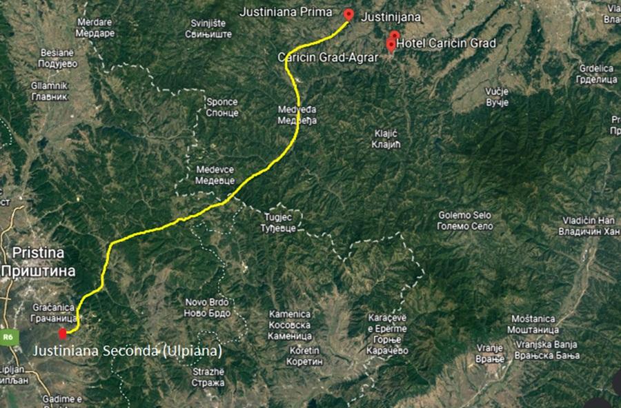
The ancient road that connected Justinian the First with Justinian the Second
Kodra e Madhe in the village of Prapashticë is about 300 m close to Kodra e Liteci (Lutesh in the village of Marec), to the west of Kodra e Liteci is Gradishta in the village of Marec. In Gradinë, we have found many archaeological traces from antiquity, and traces from the processing of ores, in the neighborhood of Bulajve, Metoh, Simojt where mining activities are observed along the entire Prroi i Zi, near Qukë e Qelnasit and Guri i Bletës.
In the Simoj neighborhood are the foundations of a church. Above the Black Stream, on the present-day borders of the villages of Marec, Prapashticë and Keqekollë, another fortification called Makica was built, which I think was the residence of the Makolle family in the village of Marec in the earliest times.
In the Bala neighborhood of the village of Prapashticë, in the locality called Nekshur, remains of old residential buildings have been found, and burial mounds called Gomuri. In this neighborhood, the foundations of a church have been discovered, as well as some ceramic vessels and two pitos. To the east of the Balaj neighborhood, there is the Roga e Konaçeve, which is thought to be a cult object, and a fortification that is today called the Bilalli guest house. It is thought that this was the castle, where the inhabitants of the Kalaja neighborhood of the village of Dabishec once lived.
According to scientific sources and traces of field research, we understand that the overwhelming population of these villages is an indigenous Dardanian population with ancient roots of pre-Dardan civilization.
Bibal settlement, today the Bala neighborhood in the village of Prapashticë
Based on written sources from the 15th century, population censuses, and toponyms, I have come to the conclusion that the majority of the population of this village is an autochthonous Albanian population, who for centuries preserved the language, tradition, culture, and original toponyms in the Albanian language. From this we understand that the population of today’s Gallapi, in general, was Albanian, was autochthonous since ancient times, and was the bearer of economic, administrative, and military development in the kingdom of Dardania.
According to the census of the population of Kosovo, at the end of the 15th century, in the Ottoman register, which included the area of Novobërdë, we find the village of Prapashticë, registered in the district of Treboshnica, with the name Prapatinça. This notebook was found in the archives of the Turkish Prime Minister’s Office in Istanbul, in 1986. [15] In this notebook, we encounter the village of Berkovica with other villages such as: Maroje-fc (which I think is today’s Mareci), Manastir (not yet published, but it is likely to be Roga e Konaçeve, in Lugu i Manastir near Llapside, in the village of Gllogovicë), Kolla e Gjergjit (it could be today’s Keqekolla), Zllash (today’s Zllash), Gradishta village (I think it is Gradina in the village of Marec), Lutesh village (I think this should be confused with Kodra e Liteci, in the Canajve neighborhood of the village of Marec, which is adjacent to Kodra e Madhe and Lugjet in the village of Prapashticë). It is noted that Berskova, listed in this notebook, has been preserved and listed as a toponym to this day, by the indigenous Albanian population in the village of Prapashtica, along with other toponyms in the area. Based on data from the field, it is noted that the researchers in question have not done any research to locate the location of Bërskova. Based on some data, it is likely that this location is Breskovica in the village of Prapashtica, where this toponym is still preserved in the Balave neighborhood of this village. Other convincing data are the locations of more than five Catholic churches, spread across almost all neighborhoods of Prapashtica.
In written documents, this settlement, with the name Prapatinza, is registered in the debtors’ register of the merchant Mikel Llukar in the first half of the 15th century. In the cadastral register of the kaza of Artana from 1498, the settlement Prapatinca is registered, with 36 heads of households and hamlets. Later, it is noted with the emir Papratincë, in the cadastral register of the sandjak of Vushtrri, from 1566-74 with 17 houses and 5 singles. It is registered with the name Grapasnica on an Austrian map, drawn up based on records from 1689. [16]
In the Ottoman book from the end of the 15th century, discovered in the archives of the Turkish Prime Minister’s Office in 1986, we find many heads of families who testify to Albanian ethnic affiliation, such as: Niksa Rajini, Stepa Marko, Raja Lisic (I think today’s Lisi-Lisica), Leshjana the widow, Bashtina Tusha in the hands of Papas, bashtina vogla (small bashtina). In this book, we find Brekovica as a village in itself, with these family members who also testify to Albanian ethnic affiliation, such as: Nikolla Dimitri, Raja the son of Dimitri, Stepan Dimitri, Marko Dimitri, Peja Milushi, Milush Marki, bashtina Bogdani, etc. [17]
In the census during the time of Sultan Selim II, in the 16th century, in Prapashtica we find Marko Mati as the head of the family, and even today in the Balave neighborhood, we find the micro-toponym Bregu i Matës , then Lugu i Pjetr (Today Lugu i Selimit) , etc. [18] In Prapashtica we also find these other heads of families such as: Lleshko Dane, Lleshko Dimja, Lleshko Rajko, Gjuro Lleshko, etc. Which prove the Albanian ethnogenesis of these heads of families. [19]
In the works of Dr. Rexhep Doçi in the book “ Anthroponymy of the Albanians of Kosovo ” we encounter in the vicinity of Artana the anthroponyms Balich and Baran which are mentioned in 1438. [20] I think that the proximity between the neighborhood of Balave and the anthroponym Bara in the village of Krilevë enables the connection with these names when we consider that the distance between these anthroponyms and Artana is somewhere around 15 km. Between Balave and Bara in the village of Krilevë, today lies the settlement Rapuha.
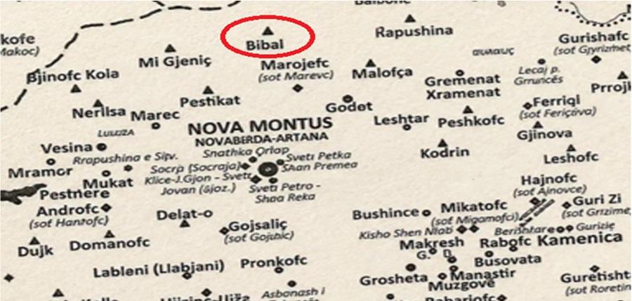
Map made according to Ottoman census and records from the 15th and 16th centuries, the villages that belonged to the Kaza of Artana.
Based on the map shown above, the Bala neighborhood in the village of Prapashticë appears to have been registered under the name Bibal. The territory of this neighborhood, even today, borders the present-day Canajve neighborhood, in the village of Marec, and Rapuha in the village of Krilevë, (see the map above (Marojefc and Rapushina), and compare it with the territory of these settlements shown and marked in the photo below.
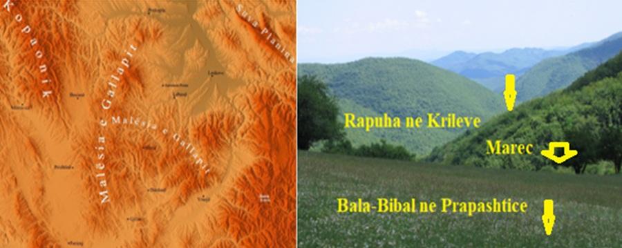
Map of the Galab Mountains, in the central Dardania region, Rapuha in the village of Krilevë, the village of Marec and the Bala neighborhood in the village of Prapashticë
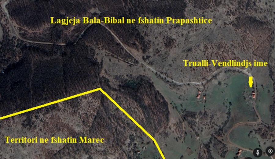
Today’s neighborhood of Balave in the village of Prapashticë, exactly on the south-eastern side where it borders the village of Marec and Rapuha in the village of Krilevë
Recent DNA analyses are proving that Dardanian populations, mainly with the J2b-L283 haplogroup, have lived in this region since the Bronze Age.
This has been confirmed by laboratory analyses and tests conducted by many residents of these neighborhoods and other villages in the area.
One of the residents of this region, and the Bala neighborhood in the village of Prapashticë, is me, who took the genetic test 10 years ago in the U. S. A, together with my colleague archaeologist Luan Gashi from the village of Mramuer, and both of us turned out to be indigenous inhabitants of these hills. Also, the genetic test, which my brother Ismeti took later, turned out to be the same as my test.
The results of our tests proved that we have an autochthonous, Paleo-Balkan (Illyrian-Arbërrian-Albanian) origin in these geographical areas.
The results of our tests prove an indigenous Dardanian population, at least since the Bronze Age. From some information, I have long understood that there are also some residents of the Bala neighborhood who have done the genetic test, and prove such a result, but I lack their results to publish.
The results of these genetic tests on the residents of this neighborhood dispel the assumption, from many stories and legends, that are embedded in the minds of many residents, that they came from some other place in these regions.
Below I am offering, the result of my genetic test done in the USA, in 2015.
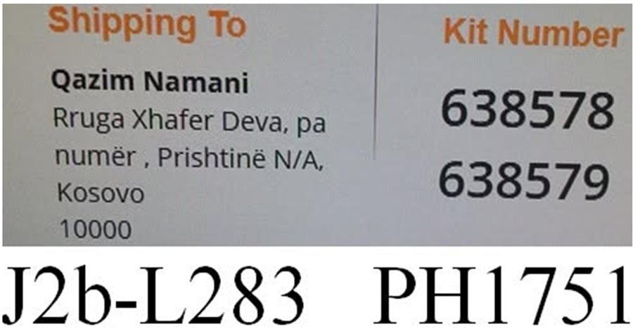
The result of my genetic test, done in the US A
To prove the autochthonous nature of the Albanian population in the Illyrian territories, it is in the national interest for any citizen to take a DNA test to publish the test results, so that we can have a clearer picture of the autochthonous nature and the development of civilization, from antiquity to the present day in Dardania.
The results so far are satisfactory, and prove that the bearers of civilization in these lands are us, the Albanians of today.
To see the percentage and purity of our genetic tests, I am publishing the results of my brother Ismet’s test, which he had done in Germany. Since his test aroused interest at the German institute, to delve deeper into the study of family genes, I will publish the graphs of the results.
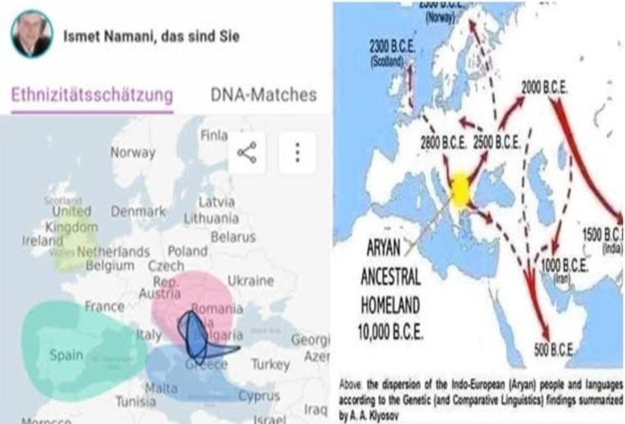
The results of Ismet’s brother’s genetic test, which proves the spread of this haplogroup from central Dardania, to Constantinople, Crete, Southern Italy, Spain and England
Residents of the Balaj neighborhood, and residents of other neighborhoods, in other villages, must create the conviction and trust that you are indigenous to these lands, you are descendants of the true Dardanians, who left traces of civilization and civilization in these lands, from the Stone Age to the present day.
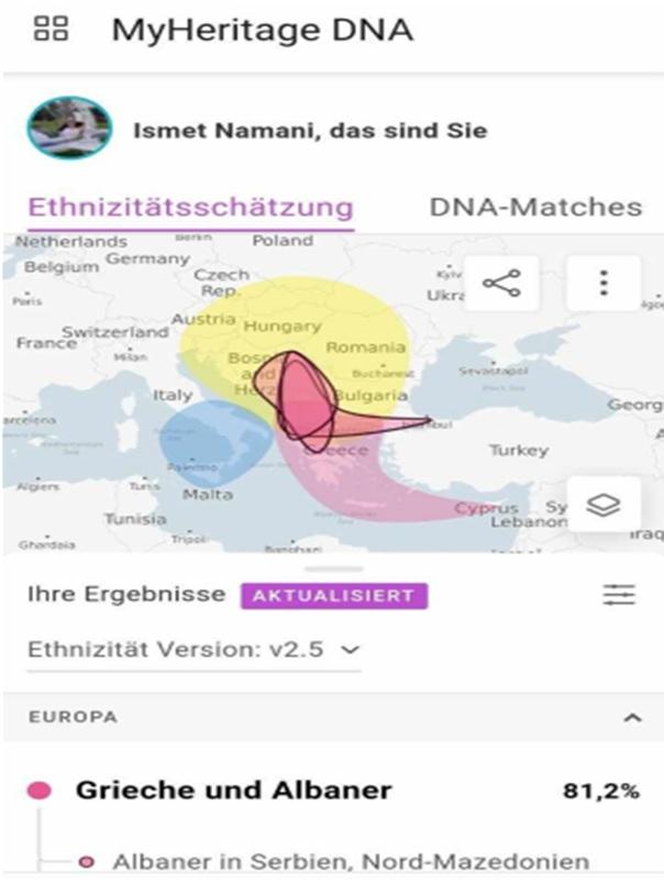
The results of Ismet’s brother’s genetic test, which proves the spread of this haplogroup from central Dardania, to Constantinople, Crete and Southern Italy.
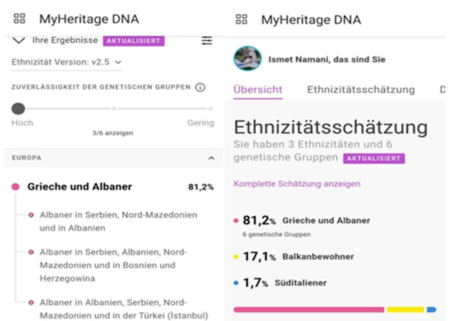
The results of Ismet’s brother’s genetic test, which proves his Dardanian affiliation and the spread of this haplogroup in neighboring territories
Migrations of the Galabroi tribe to the northern territories of Illyria, to the south of present-day Albania and to Italy.
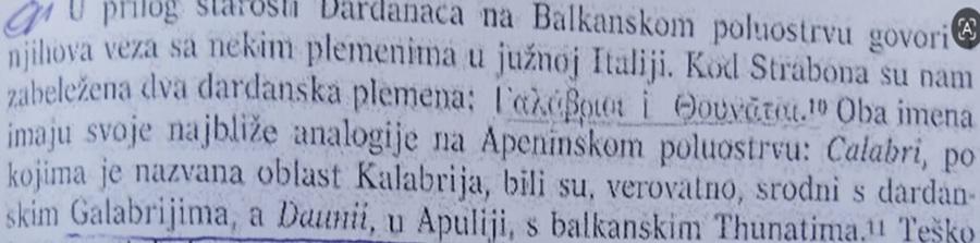
Fanula Papazoglu, written sources attesting to the Galabri and Dauni who migrated to Italy before our era [21]
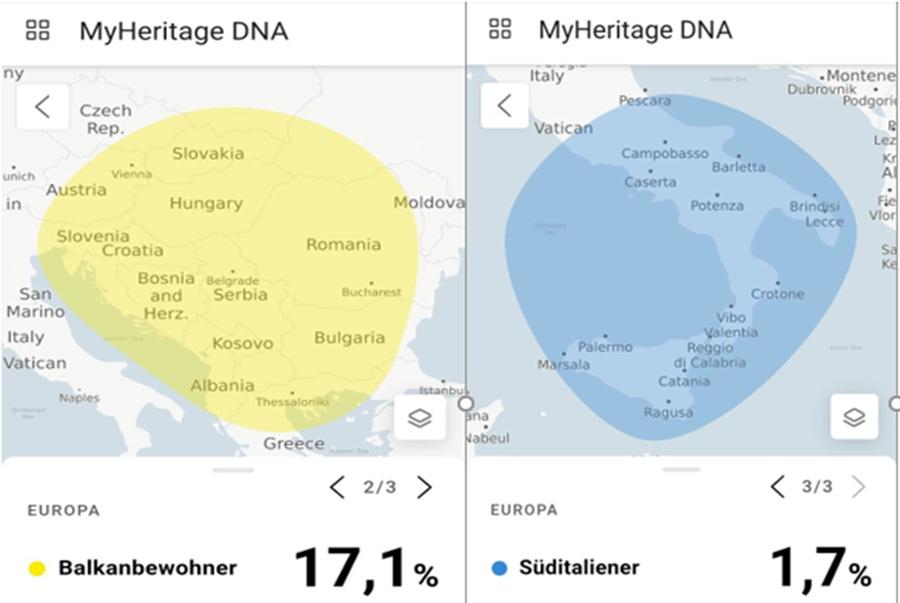
The results of Ismet’s brother’s genetic test, which proves the spread of this haplogroup to other northern Illyrian tribes and southern Italy
Haplogroup E3b (and another associated haplogroup , J2) in Britain
The family origins, arrival times, and possible migration routes of haplogroup E3b1 to Britain have been the subject of debate among population geneticists for several years. In his book, The Origins of the Britons, Stephen Oppenheimer (2006) proposed a Neolithic timescale for the arrival of E3b (and another related haplogroup, J2) in Britain , corresponding to 6.5–5.5 thousand years ago, and originating from the Balkan Peninsula. [22]
Haplogroups with E3b ? M35 and J2 ? M172 in Capelli’s study.
Correspondence to: stevenbird1000@hotmail.com Received: 1 July 2007; accepted: 15 September 2007. addressed the spread of haplogroups E3b and J in western Europe during the Neolithic era, but did not include any data from the island of Britain specifically, and built on the earlier work of Ammerman and Cavalli-Sforza (1984) regarding the “demic diffusion” model, in which the Linearbandkeramik, or LBK, culture arose after the Neolithic transition (with the Star?eves-Körös-Çris cultures), around 6000 BC or 8 kya. [23]
Semino et al. (2004) considered E3b1a-M78, of which E3b1a2 is by far the most common haplogroup in Europe, as an indicator of the spread of people from the Balkans (along with another “companion” haplogroup, J2b1-M12/M102) and therefore inherited the genetics of the spread of these haplogroups since Neolithic times.
Cruciani et al. (2007) have questioned the assumption of Neolithic dating, however, with their revised dating of the expansion of E-V13 and J-M12, from the Balkans to the rest of Europe, to a period no earlier than the Early Bronze Age (“EBA”)8. [24]
Based on extensive current research, a small percentage of haplogroup J2b has been confirmed in Spain and England.
It is important to note, and as is evident from the results of genetic tests, the genetic lineages of many indigenous inhabitants in central Dardania are not Slavic lineages, and have not been affected by the five-hundred-year Ottoman occupation.
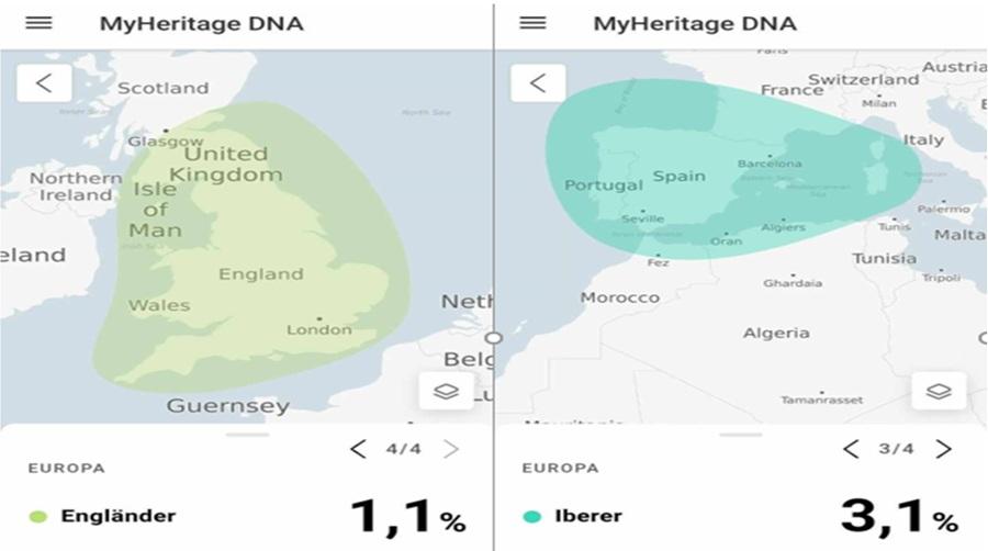
The results of Ismet’s brother’s genetic test, which proves the spread of this haplogroup in England and Spain
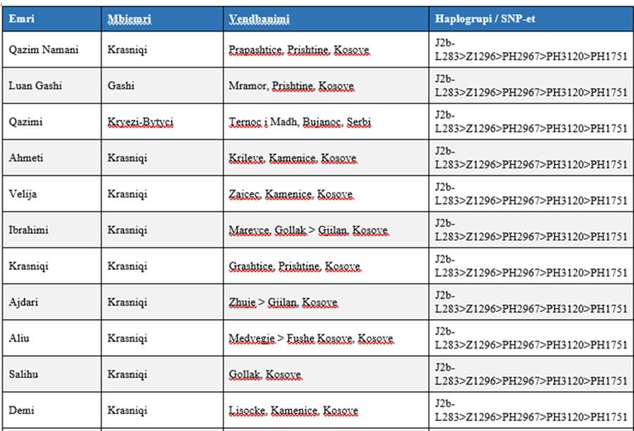
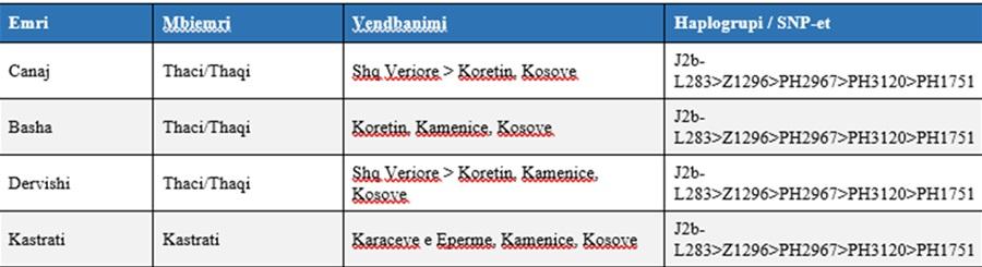
Some of the results of genetic tests, of the J2b-L283 haplogroup, from many citizens, of different villages, in the Galab region
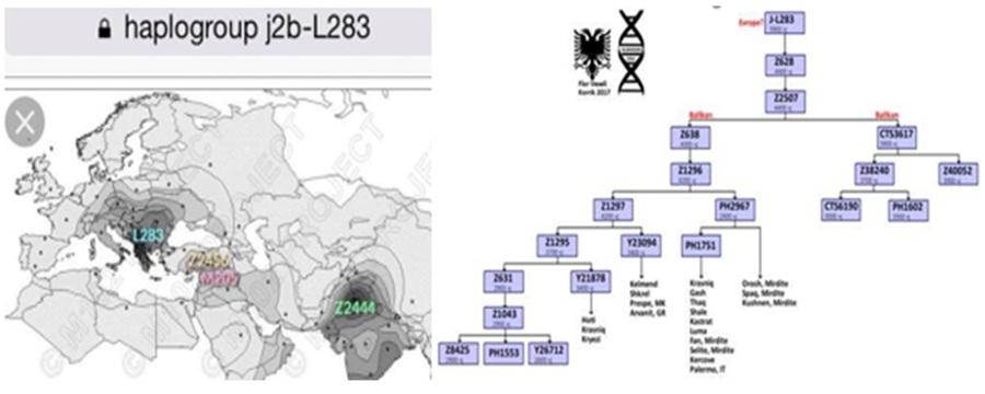
The following table includes a small number of citizens and families from several villages of the Galab Highlands, belonging to the haplogroup:
J2b-L283>Z1296>PH2967>PH3120>PH1751
Conclusion:
The autochthonous nature of the Albanian population in the Galab Mountains (today’s Gollak) is scientifically documented, through the continuity of pre-Slavic toponymy, and early Ottoman population censuses, which refute the theses of Serbian historiography, that this population arrived late, in the 18th century.
This mountainous region, which lies between the Kosovo Plain and the Niš Plain and Prokuplje, was ethnically inhabited by the indigenous Dardanian population since the Bronze Age.
As an indigenous population for thousands of years under the occupation of various peoples, experiencing murders, expulsions, assimilations, changes in toponyms, and territorial contraction, it struggled to preserve the original values of the Dardanian ethnos and culture.
The autochthonousness of the present-day Albanian population, from the Galab Mountains, has also been proven through DNA tests (genetic analysis), where the results provide a detailed overview of the antiquity of this population, in these regions, since the Stone Age. The DNA genetic code, from the test results of many inhabitants of this area, revealed the common family origin, and biological connections between neighboring and European peoples, which clearly argue for autochthonous genetic lines, and argue that these present-day inhabitants are descendants of an ancient population in our Illyrian Peninsula.
As can be seen from historical sources and the results of genetic tests to date, it is proven that the bearers of civilization in these lands are we, the Albanians of today, who live in this region rich in minerals and ancient traces of civilization.
References
[1] Illyrians and Illyria in Ancient Authors, Strabo, Rilinja 1979, Prishtina, p. 155
[2] https://alchetron.com/Galabri,
[3] Mr. MIRDITA: The ethnic origin problem of Dardanaca, VAMZ, 3.s., XLII 357–386 (2009)
[4] https://gazetadielli.com/kalabroi-fisi-ilir-pak-i-njohur-qe-i-dha-emrin-jugut-te-italise/
[5] ZefMiredita, Dardanian Studies, Rilindja 1979, Prishtina, p. 39
[6] Good morning, Dardanian Studies, Rilindja 1979, Prishtina, p. 97
[7] https://diplomacia.dk/galabret-galarbet-fisi-i-lashte-i-dardaneve/
[8] Johan Georg von Hahn, Travel from Belgrade to Salanik, Vienna 1848, p. 45:Albanian Studies, translated from the German by Veniamin Dashi, and Afrim Koci
[9] [9] MS Milojevic, Putopis, Dela Prave stare Serbije, II sveska, Belgrade 1872, pg.3
[10] Ibid., p.3
[11] Mita Rakic, “IZ Nove Serbije”, Leskovac, 1987, p. 90
[12] Mita Rakic, “IZ Nove Serbia”, Leskovac, 1987, p. 90
[13] Mita Rakic, “IZ Nove Serbije”, Leskovac, 1987, p. 90
[14] Mira Rakic, From New Serbia, Leskovac 1987, p. 16
[15] Dr. Ilaz Rexha, “Anniversary” XXVII-XXVIII p.77 Prishtina 2004.
[16] Dr. Jusuf Osmani “Settlement of Kosovo 1” p.172 Prishtina 2003.
[17] Dr. Ilaz Rexha “Anniversary” XXVII-XXVIII p.103, 77, Prishtina 2004
[18] Qazim Namani, Illyrian-Albanian Antiquity in the Gallapi Highlands, Kosovo Archives Yearbook XXIX-XXX, Prishtina 2003, p.55
[19] Muhamet Tërnava, The Population of Kosovo during the 14th-16th Centuries, Albanological Institute, Prishtina 1995, p.63
[20] Rexhep Doçi, Anthroponymy of the Albanians of Kosovo, Albanological Institute, Prishtina 1990
[21] Akademija Nauka I Umetnosti Bosne I Herzegovina, Djela Knjiga XXX, Fanula Papazoglu, Srednjabalkanska Plemena u Predrimskog Doba, Sarajevo 1969, pg. 103
[22] http://www.bloodoftheisles.net/results.html
[23] http://www.bloodoftheisles.net/results.html
[24] http://www.isogg.org/tree/

