
by Prof. Dr. Pal Nikolli
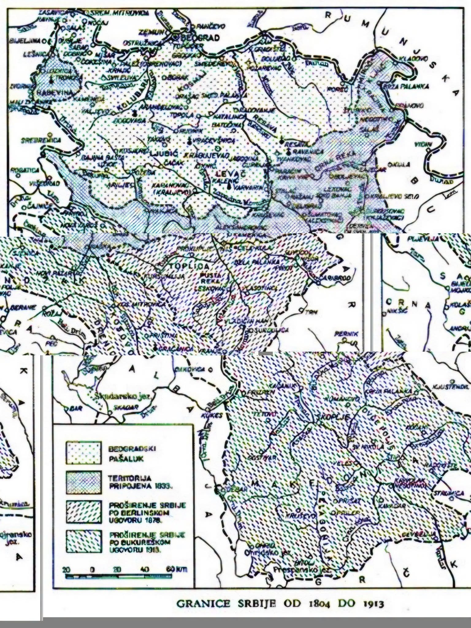
The map of Serbia’s territorial expansion during the 19th and 20th centuries cannot be read only as a history of the growth of a state. For Albanians, it is also a history of territorial losses, the secession of the regions inhabited by them, displacements and refugeeization, changes in the demographic structure, and the weakening of the continuity of Albanian space.
This is a fundamental dimension of Balkan history. As the Serbian state expanded from its initial core south and southwest, especially after 1877–1878 and then during the Balkan Wars, Albanians did not simply experience a change of line on the map. In some territories they lost their previous administrative affiliation, found themselves under a different state power and, in documented cases, part of the population was forced to leave or was displaced as a result of the war, violence and politics of the period.
The Albanian loss was, first and foremost, territorial. Settlements and regions where Albanians had been present were incorporated into the territories of the Serbian state. This was particularly evident in the areas of the Sandžak of Niš after the Serbian-Ottoman war of 1877–1878. For the Albanians of these areas, the change of the state border meant their separation from the Ottoman space and their inclusion in a Serbian national state that was building its own institutions and territorial identity.
An important distinction must be made here: the loss of political territory is not mathematically equivalent to the loss of ethnic territory. A province does not become homogeneous simply because the state border changes. But when political change is accompanied by population displacement, killings, abandonment of settlements, change of ownership, and settlement of other populations, then territorial change begins to produce a long-term demographic transformation as well.
This is exactly what historical maps should make visible.
I. The Sandzak of Niš: one of the greatest Albanian territorial losses of the 19th century.
The Serbian-Ottoman War of 1877–1878 and the subsequent decisions of the Congress of Berlin marked a significant turning point. Serbia gained new territories and its border shifted significantly southward. These areas also contained a significant Albanian population.
After the incorporation of these territories into Serbia, a large-scale process of Albanian displacement took place. In Albanian historiography and international literature, these displaced people are widely known as the Muhajirs of Niš. Many of them settled in Kosovo and other areas of the Ottoman Empire.
Thus, something happened on the map that a regular political map does not show: a territory passed from one administration to another, while part of the population living there left. The new border line was only the beginning of the process; the demographic consequence was the change in the very composition of the territory.
For the Albanians, this represented a double loss: loss of the territory where they lived and loss of part of the population that inhabited that territory.
II. From the loss of provinces to the shrinkage of Albanian space.
The process became even more profound during the Balkan Wars of 1912–1913. The disintegration of the Ottoman Empire and the expansion of the Balkan states dramatically changed the political map of the region.
Serbia expanded into Kosovo, Macedonia, and other areas; Montenegro extended its control into Albanian territories; Greece expanded its territory to the south. Meanwhile, in 1912 the Albanian state was created, but its internationally defined borders in 1913–1914 included only a part of the area inhabited by Albanians.
This created one of the greatest paradoxes of modern Albanian history:
Albanians gained a national state, but the Albanian state did not include all territories with an Albanian population.
As a result, Albanian territory was divided between several states. Kosovo and other Albanian territories remained outside the borders of the Albania created in 1912–1913. This was not just a geographical loss; it created a permanent division between the territory of the Albanian state and the space inhabited by Albanians.
III. The loss was not just land: it was also demographic.
One of the most common mistakes in reading historical maps is to look only at the surface. But territory without population is only half the story.
In many of the territories included in Serbian expansion, Albanians faced various consequences: killings during the conflicts, displacement, flight, loss of property, administrative changes, and pressures to leave. The intensity and nature of these processes varied by time and place, so each case must be documented separately.
But from a long historical perspective, the result was significant: in some areas where Albanians had had a significant presence, their demographic weight weakened.
Thus, the map of territorial expansion must be read together with the map of migration. Only by superimposing these two maps on top of each other can the connection between border change and population change be fully demonstrated.
IV. Another loss: the interruption of territorial continuity.
For Albanians, the broader consequence of the territorial changes of 1878–1913 was the political fragmentation of their national space.
Instead of a single administratively connected space, a mosaic of Albanian territories within different states was created. Albania constituted only a part of this space; other parts remained in the Kingdom of Serbia, Montenegro, and Greece.
This made the Albanian question fundamentally different from the territorial project of neighboring states. While Serbia was expanding its state territory, the Albanian political project faced the opposite problem: how to preserve and politically unite a space that was being divided between other states.
In this sense, the League of Prizren of 1878 cannot be separated from the territorial changes of the time. It emerged precisely at a moment when the issue of protecting Albanian territories had become a central political issue.
V. The map shows what statistics often hide.
A comparative map of 1877, 1878, 1912 and 1913 could show much more clearly the extent of the transformation.
One map would show the territory of the Serbian state before the expansions. Another would show the territories acquired after 1878. A third would show the expansion of 1912–1913. And on these maps, the layers of populations, Albanian settlements, migration routes, and resettlement areas should be placed.
Only then does it become apparent that the territorial expansion of Serbia and the contraction of Albanian political space were two processes taking place in the same historical landscape.
Therefore, the question should not only be: “How much territory did Serbia gain?” The question should also be: “How many Albanian territories were separated from their previous political space, what happened to the populations living there, and how did the demographic map change after the border changes?”
This approach shifts the analysis from a purely state history to a history of territory and people.
VI. A historical balance that should not be hidden.
For Albanians, the period 1878–1913 marked a series of interconnected losses:
– territorial losses, due to the incorporation of Albanian-inhabited regions into other states;
– demographic losses, due to migrations and subsequent changes in population structure;
– property loss, in cases where the displacement was accompanied by the loss of land and property;
– political loss, because a large part of Albanian territory remained outside the new Albanian state;
– loss of territorial continuity, due to the division of the Albanian population between several states;
– and loss of the opportunity for an early consolidation of a unified Albanian political space.
These losses should not be treated as a single statistic nor reduced to a nationalist formula. They should be measured and documented province by province, year by year, by comparing political maps with demographic records, diplomatic documents, traveler accounts, Ottoman, Serbian, Albanian and international sources.
This is what makes the historical map a powerful scientific document: it doesn’t just show where the border was crossed. It forces us to ask who lived there before the border was crossed, who stayed behind, who left, and how the territory changed after they left.
In this perspective, Serbia’s expansion and Albanian losses are two sides of the same historical map. One shows the expansion of Serbian state territory; the other shows the contraction of Albanian political space. Both must be presented together, because only in this way can the territorial transformation of the Balkans at the end of the 19th century and the beginning of the 20th century be truly understood.
The history of borders, after all, is not just a history of lines. It is a history of the people who lived on both sides of those lines.
Source.
Prof. Dr. Pal Nikolli. Gazeta Dielli – Faqja Zyrtare.

